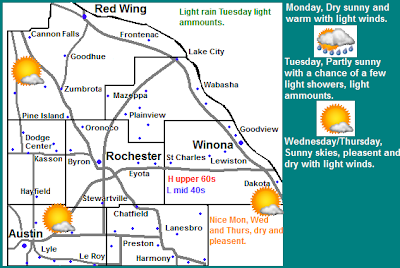
Regional Weather View.
A high pressure will move in after a stormy end to last week which will bring in a seasonably warm drier pattern for Monday. Tuesday will be the only chance of rain and it will be light as a systems moves across Northern Minnesota, the threat for rain will remain mainly in Minnesota and Wisconsin. Wednesday and Thursday sunshine and seasonable warmth will move back into the picture for all areas.
Local weather view.
Local and metro views.
Locally a high pressure system will bring us pleasant weather and we can expect a much more quiet start to the week in weather. Monday will feature plentiful sunshine with seasonable temperatures near 70 with lows in the mid 40s. Tuesday will be our only chance at rain and it will be light in nature and there will not be severe weather threats with it. Rainfall amounts should be under 0.25". Besides the threat of rainshowers skies will be partly sunny with highs in the low 60s and lows in the mid 40s. Wednesday and Thursday will be much like Monday, they will both have lots on sunshine with highs nearing 70 and lows nearing 45 to 50.F It will generally be a great week to get outdoors!
Monday, Sunny and pleasant. Light winds. Highs in the upper 60s. Monday Night, Partly cloudy with lows in the upper 40s.
Tuesday, Partly Sunny with a chance of light rain. Highs in the mid 60s. Tuesday Night, A chance of showers, lows in the mid 40s.
Wednesday, Sunny skies, pleasant and nice with highs in the upper 60s. Wednesday Night, partly cloudy with lows in the mid 40s.
Thursday, Sunny skies pleasant and nice with highs in the low 70s. Thursday Night, Clear skies with lows in the low 50s.
Looking Ahead
Friday a cold front will push through which could bring a quick shot of thunderstorms before it dries out and turns sunny and seasonable just in time for the weekend, it looks dry and sunny with highs in the 70s for the weekend, this weather lasts into early the week of the 14th until about Tuesday the 15th when a warm front moves towards the region and starts bring the threat for thunderstorms. Thunderstorm chances, warmth and humidity increase for the rest of that week in to the weekend of the 19th. There is a threat for thunderstorms almost every day, Saturday the 19th could bring heavy rain and severe weather. Then to start the week of the 22nd it becomes very warm even hot and stormy. There could be several threats of severe weather as we continue to move into the weeks of Mid May.


No comments:
Post a Comment