Map Image Legend Image

Iowa Weather Network Warnings Map

Iowa Weather Network Warnings Map

Winter Weather Advisory

Thursday, September 27, 2012

Fall Color Report # 4 Moderate Color Reported Cannon Falls and Austin 50-75%. Low color everywhere else 25-50%.

Photobucket
Fall Color Report # 4 September 27th 2012.

Fall colors are really getting a jump start across Southeastern Minnesota! Warm daytime temperatures are causing trees to rapidly change colors.  Cannon Falls and Austin are reporting Moderate color. Here earlier and mid changing trees are producing high color in beautiful shades of orange, maroon and yellow. Low color is being produced everywhere else, but these areas are picking up quickly and will likely be reporting moderate color in just a few short days! Fall colors are this rate are actually occurring slightly earlier then normal, we could be peaking in color in some areas by the end of the 1st week of October. Typical peak time for Southeastern Minnesota is the 2-3rd week of October.

 Photobucket
Fall colors in Ash and Maple along 4th St SW Sept 27th

Fall colors are really picking up big time here in Rochester. Streets with Ash and Maples, both Sugar and Reds are beautiful! Ashes have turned golden yellow and I've seen Maples in colors of yellow, orange and red. Burning bushes are also turn stunning colors of blaze red. I would rate Rochester's color around 45% and we are quickly approaching the moderate color range.

Photobucket

Fall color in Sugar Maples near 6th St SW Sept 27th

Sugar Maples are always one of the best fall color producers!

Photobucket 
Front yard ash turned Yellow. Sept 27th

The tree in our front yard literally went from green to yellow in a one week time span. I could just see that it was beginning to turn and now it has completely turned a beautiful golden yellow.

Wednesday, September 26, 2012

Very dry weather pattern in place next several days. Sunny every day, temperatures in the 70s with calm winds.

Photobucket
Regional weather view.

An area of blocking high pressure will bring a long string of sunny calm days to all of the Upper Midwest for the next week. This is unfortunately bad news because it is worsening drought conditions across this region which really needs widespread good rainfall. Look for every day to repete its self with highs in the 70s region wide.

Photobucket


PhotobucketLocal and Metro views.

It is very easy to be a forecaster this week becasue the weather will be quite boring for the area. Every day will repeat it's self one after another. The only slight difference will be temperatures, which will be very mild and pleasant for this time of year. We can expect highs starting in the lower 70s on Thursday, warming to the mid to upper 70s for Friday and through the weekend. Lows will generally be in the lower to middle 40s, warming to the 50s each day. We can expect this type of pattern through at least Tuesday of next week as an area of high pressure remains situated over the area. This pattern will lead to expanding drought. I don't see any chance of rain until the end of next week.


Thursday, Sunny nice and mild. Highs in the upper 60s to lower 70s. Thursday Night, Clear skies, lows in the lower to middle 40s.

Friday, Sunny, nice, Warm!  Highs in the mid to upper 70s. Light winds. Friday Night, Clear skies, lows in the mid to upper 40s 

Saturday, Sunny skies, nice, warm! Highs in the low to mid 70s. Saturday Night, Clear skies, lows in the mid to upper 40s.

Sunday, Sunny skies, nice and warm! Highs in the low to mid 70s. Sunday Night, Clear skies, lows in the mid to upper 40s.

Monday, Sunny, Warm! Highs in the mid to upper 70s. Monday Night, Clear skies, lows in the upper 40s to low 50s.

Tuesday, Sunny and warm! Highs in the upper 70s. Tuesday Night, Clear skies, lows in the upper 40s to lower 50s.   

Looking Ahead

Wednesday and Thursday the 3/4th looks like another warm sunny day for the area. Highs may be in or around the 80s. Friday the 5th our next chance at seeing rain, and things look a little interesting with this system but only to a point because models have been very un reliable at predicting rain this year. The model shows widespread rain across all of Minnesota Friday the 5th into Saturday the 6th. A cold front swings through Saturday bringing significantly colder air into Minnesota. There might be some snow in Northern Minnesota with that system as it exits. Dries out, and remains on the cooler side for Monday the 8th, and remains cool, dry and sunny through the 11th of October.


Monday, September 24, 2012

Fall color report #3 Rochester, Red Wing and Winona joining rest of area in low color. Southeastern areas around Preston still seeing little in the way of color.

Photobucket

Fall color report 3 September 24th 2012

Fall color is beginning to get a bit of a boast across our area. Color is really starting to increase as the days continue to get much shorter and the sun angle lowers. Now, all areas accept for the southeast is reporting low color. Trees like Ashes, Maples, Sumac, area really showing plenty of color currently. Yellow, Orange and Red can all be seen. Shrubs like Dogwood and Burning bushes also also showing signs of maroon and fiery red color. For a map of colors across the rest of Minnesota see the Minnesota DNR website
Photobucket
Sugar Maple September 24th 2012

Around Rochester I've mostly noticed Sugar Maple and Ash trees turning the most. The ash tree in the front yard is really starting to turn yellow at a fast rate. I've seen a few neighborhood burning bushes turning red as well, but when I look across the landscape, the primary color is green.

Photobucket
Asters  in full bloom September 24th 2012

One thing for sure is fall color in blooming flowers are peaking right now. This is a relatively new plant for me, I got this plant originally from Wisconsin last year. I really this perennial because of the very showy flowers fairly late in the season. These are among the last flowers to bloom in the Upper Midwest. They are a little earlier then normal this year due to a warm spring, typically you would see them blooming in mid October. They have really proved to be a great addition to the garden, and because there late season flowers there are hardy to frosts and cold!

Sunday, September 23, 2012

Freeze/Freeze this morning, lows ranged from the lower 30s to as cold as the upper 20s. Growing season has ended for most of the area.

Photobucket
Widespread frost in the back yard on the morning of September 23rd.

It was a cold morning throughout the area today as the 1st very cool frosty night of the season occurred behind a system that brought the 1st snowflakes to Northern Minnesota. The cool conditions send temperatures falling into the upper 20s to lower 30s across most of the area, ending the growing season for most places. What is interesting though, corn across the countryside was completely un effected by the freeze because it has already matured because of a very early planting season. In my backyard we had a hard frost, the backyard was completely covered with frost, tender plants I did not cover to protect it had fair amount of damage, about half of my pumpkin leaves were hit, still it was not a completely killing frost in because were kind of protected by the city. This frost/freeze came a little earlier then normal for what is expected in Southern Minnesota. Early October is more typical for the first hard frost. Compared to last year temperatures of this magnitude it occurred earlier on the 15th of September.


Lows reported Sunday Morning.

Here is a list of low temperatures seen. The coolest reading area wide was 28.F at Dodge Center, Mazepaa, and Dodge Center. It staid a bit warmer toward Preston where the low was 32.F. In the Rochester Metro, inner city areas had lows around 33.F, while outlying areas had lows ranging from 28 to 32.F.

Saturday, September 22, 2012

Very Chilly and breezy Weekend ahead. Cold front will bring very little rainfall but sigificantly cooler air. Widespread hard frosts looking likely Saturday Night lows falling to the lower 30s. Then warm up next week. Updated X1

Photobucket

Regional weather view.

The 1st very fall like weather system will be making at least a few headlines across the Upper Midwest for this weekend. A small but strong system will push a cold front through the region on Friday, bringing rain, and even a few early pre winter snowflakes to Northern Minnesota, where a bit of accumulation is possible. Behind this front cold air will pool southward bringing widespread frosts and freezes to much of Wisconsin, Minnesota and Northern Iowa. Warmer air will eventually move in earlier next week bringing more seasonable temperatures but continued dry weather to the region. Worsening and expanding drought conditions will continue for Minnesota and Wisconsin, with continuing droughts everywhere else.
Photobucket

Regional and Rochester metro views
                                                                                                                                                                                        Very chilly weekend. Highs in the 50s with widespread frosts Saturday Night. 
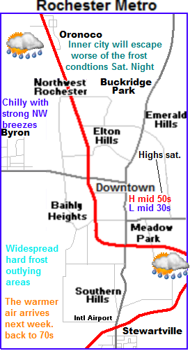
PhotobucketThis weekend is going to have a very fall like feel to it. We will have chilly conditions, clouds, breezy northwest winds and even widespread frosts.  The system mentioned above will effect the area in the following ways. Friday, will be partly cloudy with highs in the lower 60s. Showers will move in on the storms cold front. These showers will be light in nature and offer little help in the way of relief from the drought. Saturday will be kinda cold with strong northwest breezes to 30MPH. High temperatures on Saturday will struggle to reach the lower 50s. Skies will start off cloudy and then clear as the day goes on. This will set the stage for a cold night Saturday night and Sunday morning. Lows will drop off quickly after sunset. Lows will fall to the lower 30s for most areas. With a few the low valley areas possible seeing upper 20 degree readings, with these temperatures widespread hard frosts is likely . This could very will be the end of the growing season for much of the local area. Heat island effect will protect help inner city areas of Rochester escape the worst of hardest the frost/freezes, but frost is still likely in this area with lows in the middle 30s. Sunday will still be on the chilly side with highs in the upper 50s to lower 60s, and lows in the upper 30s to lower 40s.

Indian Summer? Warmer air arrives next week with dry conditions developing.

Next week for the areas the pattern turns quiet again, which is bad news for drought conditions, but it looks much warmer as warm air moves back in from the west. Next week actually looks fairl, y nice, with most days around 70s, with lows in the 40s, a few days will be on the breezy side. 

 Note: Hard frosts likely this weekend. You will want to cover tender plants! Tend plants will not survive the expected temperatures without cover. More statements can be seen above.

Saturday, Cloudy breezy and cool. Showers possible in the morning. Winds gusting to 30MPH. Highs in the middle 50s. Saturday Night, Cold! Clearing skies with lows in the lower to middle 30s inner city Rochester. Widespread hard frosts likely.

Sunday,  Chilly, Sunny skies highs in the upper 50s to lower 60s. Sunday Night, Clear skies lows in the upper 30s to lower 40s.

Monday, Sunny and Much warmer. Highs in the lower 70s. Breezy with south winds to 35MPH. Monday Night, Clear skies lows in the upper 40s.

Tuesday, Sunny, Nice! Light winds with highs in the lower to middle 70s. Tuesday Night, Clear skies, lows in the upper 40s to lower 50s.

Wednesday, Sunny skies, Nice! Highs in the lower to middle 70s. Wednesday Night, Clear skies, lows in the upper 40s to lower 50s.

Looking Ahead

Our next shot of much needed rain could arrive Thursday the 27th, when a warm front could spread some showers across Minnesota. It doesn't look like much at this time but its worth looking at. Looks dry and pleasant for the weekend into the 1st part of October. The 3rd of October a developing cold front spreads widespread showers across the region. The models shows this as being a fairly beneficial system. We'll see if it holds. I really don't see any major cool downs into the 1st week of October.


Thursday, September 20, 2012

Fall color repotrt # 2 Cannon Falls, Dodge Center, Austin reporting Low color 25% All other areas little to no color.

Photobucket
Fall color report September 19th 2012

The latest fall color report is showing color picking up in western areas of the area. Cannon Falls, Austin and Dodge Center are all reporting at least 25% color now. With little to no color in central and eastern area. Color is higher in areas where drought is more severe. Trees showing colors right now include earlier changing trees like Ash, Sugar Maple, Sumac and Burning bush.

Photobucket
 Fall color appearing in a Green Ash tree September 19th 2012.

I've just starting to notice fall color appearing around the city. I've seen a few Ash trees and Maples turning colors. Still color is still fairly hard to find right now, as typical peak time is still a few weeks away. I suspect with the warm up next week color will really begin to show up!


Tuesday, September 18, 2012

Chilly morning this morning! Lows fell into the middle 30s some areas with 1st frost of the season.

Photobucket
Lows this morning, September 18th 2012

It was a chilly morning across the area thanks to the arrival of a chilly, fall-like airmass from the north that arrived early Monday on blustery northwest winds The 1st frost was observed with these temperatures in many spots. Skies were slow to clear yesterday but once they did towards evening things became mostly clear, this helped influence the temperatures last night. Lows across the area were generally in the mid to upper 30s with the exception some extremes, like Winona and Zumbrota, which both had a low of 34.F, the landscaped influenced this some as cooler air sinks into the lower valleys that those two cities are located. In these locations frost was probably more widespread and possibly more damaging. On the other side of the spectrum, areas of deep within the city of Rochester had lows in the 40s because of a heating effect from the abundance of buildings and heated surfaces like parking lows and roads.

Interesting statement

The low at my station in West Downtown Rochester was 40.F Interestingly enough though, I did see a tinging of very light frost in the yard this morning even though the low was 40.F. The frost was so light that it was difficult to see and did not harm any vegitation. It was possible for the frost to occur because air cools as much as 10.F on clear nights as you approach the grounds surface, and it warms as you go up in feet to a certain extent. My weather station is up 6 feet above the ground because that is national standards for height. Even this being the case it is still this is the warmest temperature at 6 feet that I've seen frost occur on the ground.