Regional Weather View
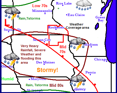
A very potent and active weather system will produce a wide range of issues for the Upper Midwest this weekend. With the weather pattern is set up the way it is currently, several waves weather are expected to pass through the region bringing concerns of heavy rainfall and river flash flooding and severe thunderstorms and tornadoes to a wide part of the region, but especially across the state of Iowa. The cause of the active weather is a warm front which has been parked over the region the pass few days and will continue to remain over the area. Warmer temperatures and more humid air will result as the warm front inches farther north into the state of Iowa and Southern Minnesota.
Local weather view
Local overview
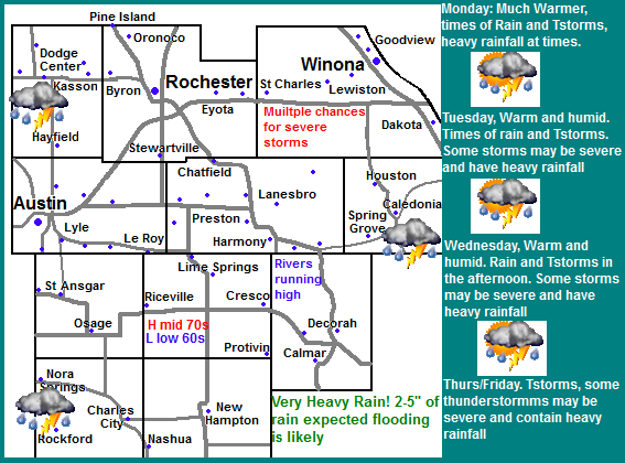
The warm front mentioned above will make a slow move northward through our area and then park its self over the area over the period of the next several days. The warm front will force in much warmer more humid air, however significant amounts of moisture will be available which will spark several waves of rain and thunderstorms and this will cause problems for the local area. With the expected system locals can expect concerns of very heavy rain and river flash flooding and several severe thunderstorms risks. Widespread very heavy rain is likely with amounts ranging from 3-5" over the Iowa communities and 1-3" across the Minnesota Communities. Rivers are already very high from the past few weeks rainfall. Flooding concerns are to a very high level for areas and communities along creeks and rivers with the areas of highest concern are along and south of the Iowa border where much of the heavy soaking rains. Also a concern is that conditions are right for several waves of severe thunderstorms with hail and highs winds as well as a tornado threat. People should be aware that there will be several days in a row with these risks. Monday through Friday will carry the risks for severe storms and heavy rain.
Memorial Day, Times of rain and thunderstorms, some storms could be severe and contain heavy rainfall. Highs in the upper 60s. Monday Night, Times Showers and thunderstorms, lows in the low 60s. Some storms could be strong and produce heavy rain
Tuesday, Warm and humid. Times of rain and thunderstorms. Some storms could be severe and contain heavy rainfall. Highs in the upper 70s to lower 80s. Tuesday Night, humid, Showers and thunderstorms, lows in the lower 60s.
Wednesday, Warm and humid. Thunderstorms developing, some storms could be strong to severe and contain heavy rainfall. Highs in the low 80s. Wednesday Night, Partly Cloudy, lows in the middle 60s
Thursday Partly Cloudy, Thunderstorms developing, some storms could be strong to severe. Highs in the upper 70s to lower 80s. Thursday Night, Thunderstorms, some could be severe and have heavy rain
Friday, Partly Cloudy, Thunderstorms, developing, some storms could be severe and contain heavy rain. Highs in the upper 70s to low 80s. Friday Night, Thunderstorms early, then cloudy. Some could be severe and contain heavy rain. Lows in the low to mid 60s.
Looking Ahead
Overall in the long term, expect warmer seasonal temperatures but a very active pattern to continue for the rest of the month into the 1st part of June. Into next weekend, the active weather will continue as a cold front pushes through the area, storms, heavy and severe weather will be possible through Saturday. It is now until Sunday June 2nd that the weather shows signs of clearing off and becoming dry. It has the chance to be dry and pleasant through Tuesday the 4th, before the next storm beings a wave of heavy rain and severe weather threats for Wednesday June 6th. Thursday June 7th through Monday June 10th has the chance for another dry period before the next storm arrives on Tuesday June 11th


No comments:
Post a Comment