Regional Weather View
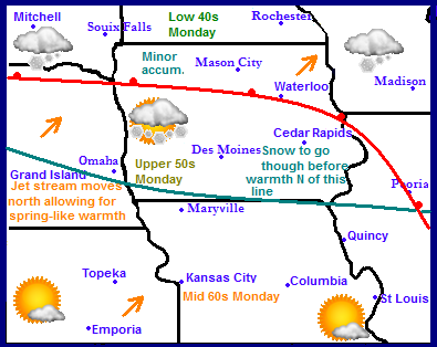
The jet stream will be making a move this week in a better direction which will bring much needed warmth into the region by the weekend into early next week, but before that happens a disturbance or two will pass along it. Areas of Northern Nebraska, Iowa, Illinois, South Dakota, Minnesota and Wisconsin will see a disturbance along the warm front that will bring some minor accumulations to those areas on Tuesday night. Thursday will be the main start of the warming trend for most areas. High temperatures will warm into the 30s, 40s and 50s region wide and stay there for several days. Snow will be melting across much of the Midwest. By Monday many areas from Southern Iowa North will see 40s, and from Southern Iowa South will be seeing 50s and 60s.
Local View
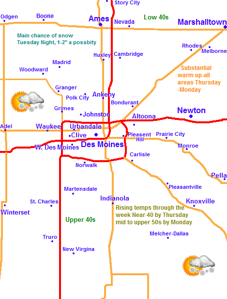
For my first local forecast I am proud to be saying there is significant hope for warmth for our area, but as mentioned above we will have some snow to get through first. Tuesday and Tuesday night as a warm front pushes its warm into our area, snow will develop. It will be on the minor side with 1-2" with possibly locally up to 3-4" the likelyhood for totals. Highs will already be much warmer in the upper 20s by tomorrow. Wednesday will be cloudy to partly sunny with highs in the upper 20s to the lower 30s, with lows staying in the mid 10s. Thursday will finally be the day that warmer weather will really begin to move in. Highs will be near 40 with lows near 30 under partly sunny skies. Friday there will be a cold front pushing through bringing a cooler shot of air for the weekend. It will be cloudy with maybe a sprinkle or two as that front goes through with highs in the lower 40s and lows cooling to the low 20s. It will be dry for the weekend into the start of next week, Saturday will be partly sunny with highs in the lower to low to mid 30s and lows in the mid to upper 10s. Sunday will be much warmer with sunshine and highs in the upper 30s to as warm as the mid 40s depending on how much snowcover still remains. Monday will be the centerpiece to the warm up with highs warming to the mid to upper 50s. Whatever snowcover is still on the ground will melt off again.
Tuesday, Light snows developing in the evening. Lows in the mid 10s. Accumulations 1-3"
Wednesday, Cloudy skies with light winds. Highs in the upper 20s to the lower 30s. Wednesday night, Cloudy with lows in the upper 10s to lower 20s.
Thursday, Some Clearing, Partly sunny with highs in the upper 30s to lower 40s. Thursday Night, Partly Cloudy with lows in the upper 20s
Friday, Cloudy skies with highs in the upper 30s to lower 40s. A sprinkle or flurries are possible. Friday Night, Partly cloudy with lows in the middle 20s.
Saturday, Cloudy skies with some clearing. Highs in the upper 20s to lower 30s. Saturday night, Partly Cloudy with lows in the mid 10s.
Sunday, Sunny and Nice! Warmer, Southerly breezes with lows in the upper 30s ranging to the middle 40s. Sunday night, Partly Cloudy with lows in the upper 20s to lower 30s.
Monday, Beautiful, Southerly breezes with sunny skies. Highs in the mid 50s ranging to the upper 50s. Monday Night, Clear skies with lows in the upper 30s.
Looking Ahead
Unfortunateally this warm up we see will not last, but the good news is I do not see anything nearly as cold as it was the past couple days either. We might be able to squeeze 1 more 40-50 degree day Tuesday before a cold front passes through. Wednesday the 12th looks sunny with highs in the upper 20s to lower 30s. Thursday the 13th through Monday the 17th the weather will range from being in the 30s to the lower 40s with the jet stream to our south once again, but from time to time meandering north or overhead, during which times it will be warmer. There will be a chance of snow or two with this as well. It will overall be cool for March standards through that time. Then towards the middle of the month with the jet stream staying just south of us around the 18th and 19th could bring some chances for wet snow with the model actually trying to show a wet-type snowstorm over northern Missouri and Southern Iowa, but there is a chance rain could mix in. Through the entire model run with the acceptation of early in the run the jet stream is nearly overhead or south which indicates a cooler then normal pattern. However like I say I do not seen Significant cold like we've been dealing with so that will make it seem better.


No comments:
Post a Comment