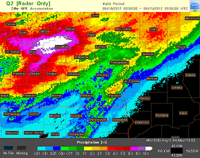
Radar estimated rainfall totals for Thursday June 14th. Image from NWS La Crosse.
Significant storms slammed into the area during the afternoon and evening hours of Thursday, as they developed along a frontal boundary and began moving southeast and bringing sigificant damage from high winds to Southwest Goodhue, Dodge, and Olmstead counties. Before this happened, thunderstorms had trained over Goodhue county and produced up to 6+ inches of rain in that region which caused severe urban, creek and river flooding to those areas.
Severe flooding at Zumbrota Covered Bridge Park
Storm initially formed on a boundary that was left from thunderstorms around the Twin Cities and Northwest Wisconsin earlier in the morning. This boundary was the trigger for thunderstorms to fire during the early afternoon hours. Early in the development strange they continued to train over Goodhue County producing widespread significant rains before storms finally sank in a southeast motion. Extreamlly heavy rain and very high rainfall ammounts effected areas like Cannon Falls, Zumbrota and Red Wing, along with the rural area in between. some actual amounts were as high as 8 inches, with the highest amount I've
seen was 8.83" near the Cannon Falls area. The heavy rains caused major road closures and many roads in Northern
Goodhue county were closed due to high water, or had been completely
washed out, Highway 52 a major north/south highway also had to be partially closed due to high water. I happened to be arriving back from my trip from Wisconsin and driving through that region I saw alot of washouts and places where corn was flattens in low spots from rushing water.
Tree blown down from high winds just northwest of the Rochester City limits.
Eventually the storms broke this boundary and began moving southeas, as this happened the storms transitioned into a high wind event.The main impact from this storm after it moves southeast was large hail and very high winds and torrential rainfall.
Radar image of the storm just before impacting Rochester. Image taken with the help of Dave Westerhaus of Isanti,Minnesota.
The storms high winds caused widespread tree damage in areas of Dodge, Goodhue and Olmstead counties as they developed into a southeast moving line. Damage was reported first in Kenyon and West Concord, which was significant in some areas and included widespread tree and even some structural damage near Kenyon. The storms continued to produce damage as they moved southeast and impacted Zumbrota, Kasson, Pine Island and Oronoco. Significant tree damage was seen especially in the Pine Island area.
Large 5 inch diameter branch down in our backyard from the June 14th storm.
After effecting these communities, the storm then and impacted the
Rochester Metropolitan area, sending torrential rain over 2 inches and 60+ MPH winds
through the city. Tree damage was reported throughout Rochester, but
especially in Rochesters North and Western neighborhoods. The tree damage
was most significant in Northwest Rochester where many trees were
downed. The KTTC News Station reported a wind gust of 62MPH in that
area. Further south in the city, Widespread large branches were down in many places in the city including my neighborhood in West Downtown. During the height of the storm multiple power outages were reported in all 4 quadrants of the city. My aunt reported to me that power was out in our West Downtown neighborhood for 6 hours, this time from fallen tree branches. She also noted the skies became very dark as the storm front moved in. I estimate the wind was at least 58MPH in this part of the city due to the amount of large branches down across the neighborhood. My rain gauge had picked up 2.64" of rain from this storm.
Large branch down in West Downtown from Thursdays storm.
Rochester Metro area reports
Northwest Rochester, 62MPH wind gust. Widespread tree damage in all neighborhoods,
West Downtown Estimated 58MPH winds, Lots of large branches down in all area neighborhoods.
Rochester, Multiple power outages in all areas of the city.
West Downtown-My Station, Heavy Rain 2.64"
Area Storm Reports
2 miles SW Cannon Falls, Heavy Rain 8.83" Roads closed due to high water.
Red Wing, Heavy Rain 6.10"
Goodhue Heavy Rain 4.43"
Kenyon Heavy Rain 4.54"
Bellchester 1.25" hail
3 miles NW Oak Center 1.25" hail
Goodhue 1.00" hail
6 miles S Wanamingo 1.25" hail
5 miles SW Wanamingo Numerous trees blown down hay wagon blown into road
2 miles S Claremont half of a tree blown over
Wasioja Lots of trees down in community, rotating wall cloud seen.
2 miles E Dodge Center, Semi truck blown over.
Genoa Trees Down
Elgin Large branches down.
Plainview, Large branches down


2 comments:
Looks like you guys really got socked Thursday, wow! We had about 1" of rain up here in Duluth, off an on strong t'storms, very dangerous lightning and 1 severe warned storm between 2-3pm.
Yeah it did really hit hard in this area while I was away, there were so many branches down across the city. I've seen that type of weather condtion Tim it is quite scary with bolts of lightning strike close.
Post a Comment