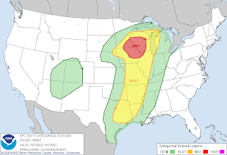
Image from SPC
A Moderate Risk! For severe weather has been pushed westward Sunday and it now includes the all of Southrn Minnesota, Northeast Iowa and Western Wisconsin. This includes the entire local area! The weather system that causes yesterdays bad weather in Kansas and Iowa will be impacting Minnesota today. Warm humid air that is starting to be put into place ahead of a east moving cold front will move east across the area later today. Thunderstorms are expected to break out in the afternoon along this cold front. The biggest threats with these fast moving stoms will be very high damaging winds, large hail, very heavy torriental rain and even a risk for tornados. People should be well awware that there is a risk of severe weather Sunday, which could become our 1st mjaor outbreak of the season!


No comments:
Post a Comment