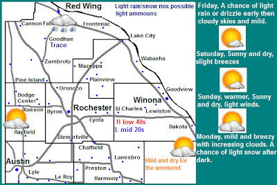
Mild and lack of weather is quickly becoming the story once again the the Upper Midwest at least for this week. One weak system and cold front will pass through tomorrow bringing light rain or snow mainly to Minnesota and Wisconsin. Behind this front skies will clear and it will be pleasant. Then late Monday a system will move into the Upper Midwest, which could being a bit heavier snows.
Local and metro views.
Note: Mondays forecast is subject to change due to un certainty of a system expected to arrive.
Locally we can expect that after a few morning wet snowflakes or drizzle with a cold front we will have a cloudy skies for the rest of that day, but it will be mild Highs will reach the 40s and lows will be in the 20s. Any snowfall amounts would be minor and not significant. Saturday and Sunday skies will clear and it will be sunny and it will cool off slightly Saturday into the mid to upper 30s before highs rise back to near 40 by Sunday, lows will be in the 20s. Most of Monday will be dry with increasing clouds and wind with highs near 40. Chances for snow will start to develop after dark. It is too early to tell how much snow will fall, but minor amounts are possible.
Friday, A chance for light drizzle or light snow in the morning, otherwise cloudy with highs in the low 40s. Friday Night, Clearing skies. lows in the lower 20s
Saturday, Cooler slightly breezy, Sunny skies with highs in the mid 30s. Saturday Night, Clear skies, lows in the low 20s.
Sunday, Sunny skies, highs in the upper 30s to low 40s. Sunday Night, Clear skies, lows in the mid 20s.
Monday, Increasing clouds. Mild and breezy with highs in the upper 30s. Monday Night, A chance for light snow. Cloudy with lows in the upper 20s.
Looking Ahead
The system for Monday Night immediately into Tuesday is still real questionable at this time, but it appears that some snow may fall here in Southeastern Minnesota, right now it looks like a warm system and it may very well fall as some rain mixing in, or it could end out being a few inches of wet snow. After this system it will cool off slightly and dry out for the rest of that week. Then around the 25th of February, a system pushed through drawing warm and northward, bringing rain changing to snow to southeastern Minnesota. It cools off slightly once again behind this before more warm air pushes back into the region, during which rain and snow become possible as we go into the 1st week of March.


No comments:
Post a Comment