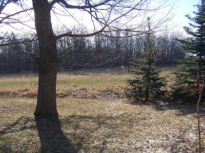
 Bare Ground December 3rd
 A System Effected parts of the area. Snow formed last night in the south. Places south of a line from New Richmond to Sand Creek got minor accumulations Menomonie picked up 2 inches Places east of Somerset got less then half an inch. While places like Amery, Rice Lake and areas north saw nothing at all. Some people around the area are looking foreword to a good snowpack for Winter sports! looks like the next snow chance is Friday Night there will be a chance of snow but it does not look like a lot. More on the forecast tomorrow.
Looking ahead forecasts.
I wanted to say something about my looking ahead forcasts. I use these to try and give some people an Idea of what to possible expect in the next few days. please Remember that what I say Might happen, may not play out in the end. I just issue these to give people an idea. I am not a professional forecaster. Thanks everyone for visiting my blog and for all your support.


3 comments:
D, reports from home state that at time of observation (24hr period ending at 10:30am) OSNW3 had recieved 2.0" (0.17") with a snowdepth of 4".
Since then, another report came in around 1pm and OSNW3 had received an 0.5" and it was still snowing.
Gotta love the wife's enthusiasm. :)
Another report just in from the wife at OSNW3... another 0.5" since 1pm. Making today's total 1.0". It's not snowing anymore. The webcam makes the ground look fluffy.
It's thundering down here in Little Rock, AR. From the radar it looks like a slow moving line of T-storms is rolling through.
Harumph. I want to be back home in the snow. *click heals 3x* :)
Thunder thats cool, yeah You need to share that snow! lol!! I would love some fluffy snow! right about now
Post a Comment