Hot dry conditions August 27th 2013
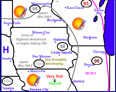
Today was another hot humid day across the area. The triple digit 6th strait day in a row of 90s. however today the heat peaked at its highest level of this heat wave. Triple digit highs were seen any many officially stations across the area including Cedar Rapids and Iowa City, which both hit 100.F. The record high of 100 set in 1953 was tied at the Eastern Iowa Airport in Cedar Rapids today. The cause of the extreme heat was because of a frontal system mixing upper level airmass to the surface, but it was also caused by several days of extreme heat allowing night time and day time temperatures to slowly warm each day while the dewpoint lowered slightly. The highest temperatures today seemed to be along and south of Highway 30, which was south of a weak frontal system
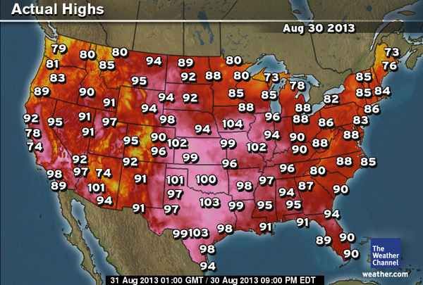
U.S highs map
This is a map showing what the highs were across the U.S today. It is easy to see the large heat bubble located over the southern and central part of the U.S, from about the southern half of Iowa southward. It is interesting to note the high was 104 in Des Monies today which broke their record for the day and for the latest 104 degree reading in the month. It is also interesting to note that out of all the stations chosen for this map Des Monies was the warmest in the South/Midwest.
Local Highs today
Downtown Cedar Rapids 103.F
Marion 101.F
Hiawatha-( My Station) 101.F
Iowa City 100.F
Eastern Iowa Airport 100.F
Marshalltown 97.F
Monticello 95.F
Independence 95.F
Waterloo 95.F
Dubuque 92.F
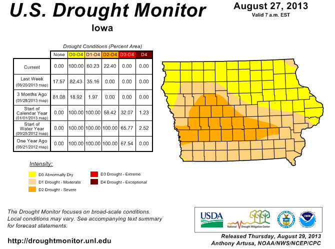
Iowa Drought Monitor
Extreme heat and lack of rainfall this month is leading to drought across the entire eastern half of the state. In all this month The Eastern Iowa Airport in Cedar Rapids has only received 0.11" of rain, and in Iowa City even less 0.08" of rain has fallen for the month. This coupled with wind and extreme heat is taking its toll on plants, Crops and other vegetation such as lawns are started to be effected and turn brown and I've seen some trees starting to loose leaves under severe stress from last years drought with the addition of dry weather this year. Fortunately we do have a 50% chance of Thunderstorms on Sunday, which is a much better chance then we've had all month. Saturday and Sunday will be much cooler then Friday was, but will still be quite warm in the middle to upper 80s. Sundays storms will be sparked by a cold front which will drop our highs temporarily into the middle 70s with lows in the 50s.


Iowa Weather Network Warnings Map

Winter Weather Advisory
Friday, August 30, 2013
Tuesday, August 27, 2013
Highs Tuesday apporached 100.F at several locations. Heat index values well over 100
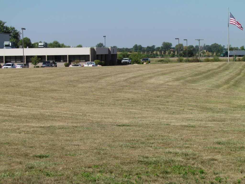
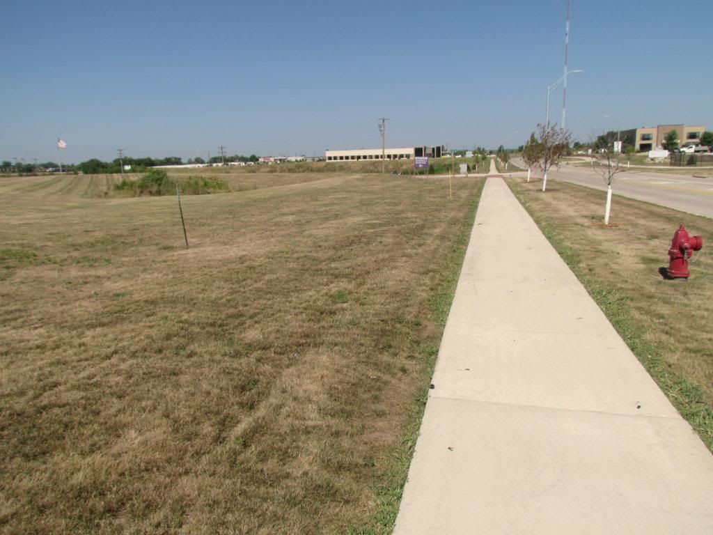
Drought conditions leading to brown grass. August 27th 2013
Today was day 3 of out heat wave and highs reached their highest levels so far this year. A ring of fire, or heat dome is situated on top of Iowa which is bringing this late blast of hot weather. Highs began to rise above 90 on Sunday and continued to rise each day until today. Temperatures Tuesday across Eastern Iowa ranged from middle to upper 90s. With the hottest conditions being found across the southwest. High dewpoints around 70 degrees pushed heat index values into 100s. The high heat, windy and dry sunny conditions is putting stress on crops and on lawns and gardens. As seen above industrial areas and very sunny lawns have turned completely brown. Heat and dry conditions will continue through next weekend with a peak again in high temperatures on Friday. The only chance for rain will be a slight chance of storms Friday night and again Saturday night. A cool down will happen for the area on Monday, when highs will cool into the 80s with lows into the 50s.
The following is a list of highs seen with heat index values.
Downtown Cedar Rapids 99.F/104.F
Hiawatha 99.F/104.F
Iowa City 97.F/103.F
Independence 97.F/103.F
Marshalltown 96.F/101.F
Mount Vernon 96.F/101.F
Eastern Iowa Airport 95.F/101.F
Davenport 95.F/101.F
Waterloo 94.F/103.F
Monticello 93.F/101.F
Saturday, August 24, 2013
Long tearm heat wave really behings to crank up starting on Sunday lasting through the week. Much of the region has the chance to hit 100.F, 100+ degree heat indexs will be seen dispite the actual highs. Drought will worsen/expand with no chances for rain this week
An unusually hot late Summer heat wave is poised to hit the region this week as a warm air mass associated with a high pressure system that has been trapped in the southwest slowly begins to push eastward in our area. This feature will keep all chances for rain out of the region bring us continued sunny skies but with temperatures and humidity heating up significantly. Highs region wide will be in the 90s, with the corridor of the hottest weather being located mainly west of the Mississippi River where cities such as Minneapolis, Des Monies and Kanasas City all have the very real chance to see triple digit highs. Record highs could be reached in some areas. The high pressure system will keep the region dry through next weekend.
Unfortunately there is no rain
For the local area we can expected that heat wave that I've talked about last week to finally make its way into our area. The high pressure system will bring a string of several sunny days in a row, each afternoon being very hot and very humid. Temperatures will range from the low to mid 90s from this Sunday through the work week to at least Saturday. A few of those days will have the chance to be 100 or close to it. Even if actual highs do not reach 100, heat index values will be 100-105 So cautions should be taken and residents should take typical precautions to beat the heat. At this point I feel the hottest days will be Monday and Tuesday when all areas of Eastern Iowa will be at least in the middle 90s. Hotter areas, river valleys and heat island effected locations such as Iowa City, Cedar Rapids and Davenport could hit 100.F. Due to high dewpoints, Low temperatures will not provide much realife and in fact a couple of nights will not have lows our of the middle 70s.
Droughts will worsen across the area
Forecast for Eastern Iowa:
Sunday, Hot! and Humid, Sunny skies with highs in the low to mid 90s. Heat index values 99-100 Sunday Night, Clear skies, Warm and humid. Lows in the lower 70s
Monday, Sunny skies Very Hot! and humid, highs in the mid to upper 90s, heat index values 99-105 Monday night, Clear skies, Warm and humid, Partly cloudy skies with lows in the mid 70s.
Tuesday, Sunny skies Very Hot! and humid, highs in the upper 90s to 100. Heat index values 99-105. Tuesday Night, Clear skies, Very warm and humid, lows in the mid to upper 70s.
Wednesday, Sunny skies, Hot! and humid. Highs in the middle 90s. Heat index values near 100. Wednesday Night, Clear Skies, lows in the upper 60s to lower 70s
Thursday-Sunday Hot! and humid. Sunny skies, highs ranging from the upper 80s to mid 90s. Thursday-Sunday nights.
Long range forecast
The long range charts do show temperatures slowly going on a downward trend after next Sunday the 1st, but do not show a substantial cool down until Friday September 6th when a cold front from Canada brings much cooler air with lower humidity with highs cooling to the 70s. This front will bring our next good chance for rain in the thunderstorms and proably the risk for severe weather with it as well. Towards the middle of the month of September the models show heat and humidity trying to rebuild. Unfortunately besides a few chances for rain, I do not really see any chances for widespread soaking rains, which will expand and worsen the drought in areas that do not receive much rain.
Thursday, August 15, 2013
Welcome to Cedar Rapids
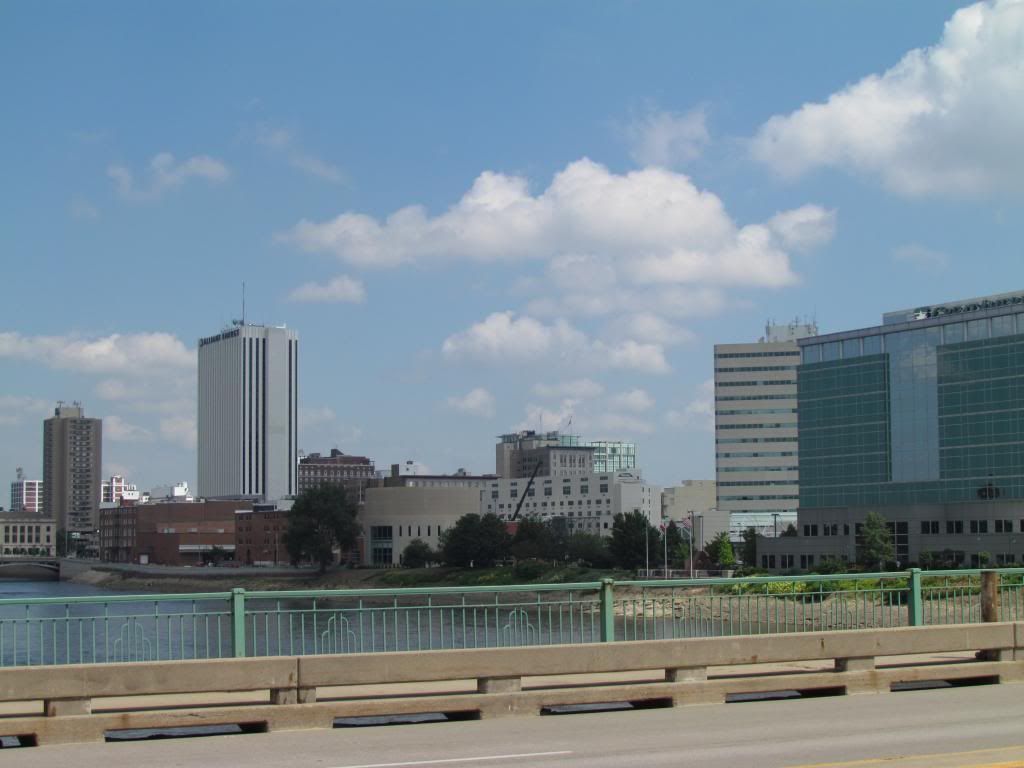
Downtown Cedar Rapids
Welcome to Cedar Rapids! I have spent the last week or so getting to know the city as well as the job which allowed me to move to the Cedar Rapids area. I have accepted a job at a local garden center where I will be working in retail/customer service. The move to the area was quick, in 2 weeks time I had a job offer and a place to live in the Cedar Rapids Suburb of Hiawatha and now that I am all settled in and un packed its time to introduce information about the area.
Cedar Rapids is located in Eastern Iowa, nearly exactly half way between the Missouri and Minnesota boarder. It is known as the City of 5 seasons, the 5th season being enjoying life and time to enjoy the other 4 seasons. Cedar Rapids is Iowas second largest city behind Des Monies. The city proper or has 126,000 residents, however Cedar Rapids with the suburbs cities of Fairfax, Hiawatha, Marion and Robins has a metro population around 200,000. Marion which is a Cedar Rapids largest independent suburb is one of the fastest growing cities in Iowa.
I look foreword to my time covering Eastern Iowas weather and serving the Cedar Rapids, Iowa City and Waterloo areas. Below you can find climate information on Cedar Rapids.
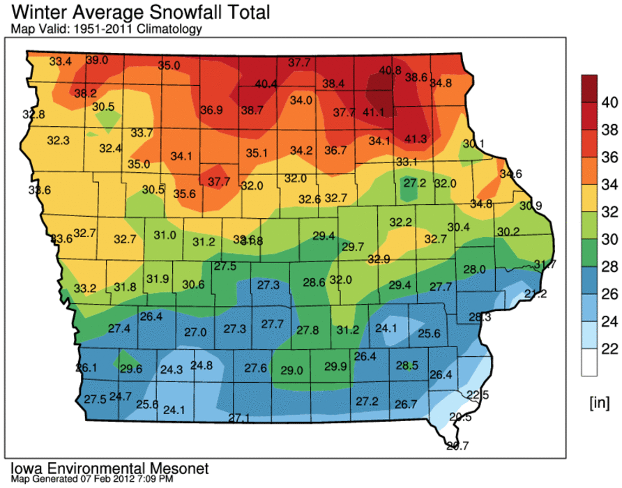
Winter Snowfall average map
Cedar Rapids has hot and very humid summers and cold, snowy winters. However it is far enough south that the winters generally on average are not as harsh, snowy or cold as winters in Northern Iowa and Minnesota. The winter snowfall average is around 31 inches, with the snowiest month being December with 8.70" of snow. The coldest month is January with an average high of 30. Summers are very humid with temperatures commonly above 85.F, in fact that is the average high for July, the hottest month on average. The wettest month is June when 5.13" of rain generally falls on average.
Being from and spending all of my life so far around Northwest Wisconsin/Southeast Minnesota, I find that it will be interesting to see how Eastern Iowa Winters and Summers compare to that region.
Subscribe to:
Posts (Atom)

