Were looking at another weather system coming at the Upper Midwest starting Sunday in SD, and Western Minnesota. Then moving east Monday. Minnesota, Western Wisconsin and Northern Iowa will have the threat for Severe Thunderstorms. then Tuesday things clear out.
Local View Updated for Tuesdays Weather.
Hot Weather Tuesday.
Things clear out, and dry out Tuesday, But it now appears like station front will not give us relief from the warm humid conditions. Temperatures will actually by Much Hotter on Tuesday as Highs will approach 90.F, Dew points will still be quite high across the local area this will cause Heat Index to get close to the 100s range. People in the area should take measures to Stay cool tomorrow
Tuesday, Clearing, Hot and Humid! Sunny, highs in the upper 80s to lower 90s. Tuesday Night. Clear Skies, lows in the mid 60s.
Looking Ahead.
The Weather Pattern is finally showing signs of calming down, but things will continue to stay hot, We could get near 90 multiple times between Tuesday through Friday. It also looks like it will be preip free, with lots of dry days. It does show a slight chance at rainfall come time next weekend August 7th and the 8th. Otherwise, The models seem consistent with another Hot air mass heading our way starting the 6th, and getting really strong by the 8th. then it shows some dry days during the week, then then Sunday 13th models show some rainfall chances with cooler conditions. More on this later.
A Picture of the massive storm front at my location July 27th. (looking West)
This post will be separated into 2 parts. one part will cover the storms in the area as a whole, and the second part will cover the storm and damage at my location.
A very Large Line of storms extending all the way from Northern Wisconsin to parts of Nebraska pushed across all of the 6 county area Tuesday. with reports of a lot of Wind Damage, including some significant strait line wind damage, and some damage that was from a tornado. The main damage area seems to be centered around the Balsam Lake, Turtle Lake and Almena areas north to Cumberland, with lesser wind damage south.
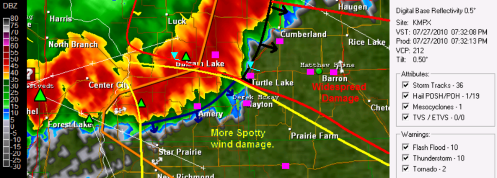
GRl3 radar image with narrative lines (Pink squares are damage/Strong wind reports) Large image Here
This line of storm first developed in Minnesota, producing wind damage across the Northern Twin Cities Metro, It weakened slightly, then really bowed out as it reached St Croix Falls, When it bowed out it started producing significant wind damage. A small brief tornado dropped and effected the Village of Balsam Lake, knocking down trees and signs the tornado was rated EF-0. This significant wind continue East to the Cumberland, Turtle Lake and Almena east to Cameron taking down trees power lines down and even causing structural damage just north of Turtle Lake, It was confirmed that a tornado passed just North of the Village of Turtle Lake, This tornado ripped siding off homes and destroyed sheds and roofs, it was a confirmed EF-1 A 3rd EF-1 tornado was confirmed north of Chetek (full list of reports at bottom) As the radar suggests above, the strongest winds seem to be where the tip just west of Turtle Lake starts and it continues North from there, Winds in the area could have been between 60 and 70MPH. with a 2 tornados, one in Balsam Lake, and the other near Turtle Lake. Winds appear to be less extreme south of this area with gusts as high as 45 to 50MPH effecting places like Amery, Clayton & my location, Clear Lake, Star Prairie and Deer Park into Northern Dunn County.
Tree damage in Turtle Lake Photo by Alan Gabe.
The Community of Turtle Lake just to my north got hit very hard with this storm. My friend reported that there was trees and power lines down in and around Turtle Lake blocking roads, as well as siding torn from parts of a the hotel on the West side of town Highway 63 near Turtle Lake was closed due to fallen trees. with the tornado passing less then 2 miles from town to the North and Northeast the damage to this area was more significant.
Storm at My Location
Second Image of the Storm front (Looking North towards Turtle Lake)
This line of storms brought Very Strong winds to my area, The strongest winds that I have seen in many years. As the storm came in, I could see a massive storm front ahead of the storm, and in all my years of storm photography i have never seen a wall of clouds above the storm front like this. I could tell by the looks and speed of these clouds, and radar images that the winds were going to be very strong, but it wasn't until Damage reports came in from Balsam Lake before I realized my home and community was in danger and people needed to be inside, because this storm reminded me a lot of the strait line wind event of June 2001 This is one last image of the storm clouds showing just how threatening the skies looked, I've never seen this much green in storms before!
Storm Footage of the strongest winds.
I decided I was to film the winds from our poll shed on the Northwest side of the yard so I could get full view of the trees, but I was glad the winds were not much stronger then they were, because the shed started to rattle under the strength of the winds. I seen the strongest winds came just before the rain hit, just as the huge shelf cloud in the pictures above pasted, It went from dead calm to windy like in this video in the madder of minutes. Video still of the Backyard tree enduring the strongest gusts Est. at 50MPH
During the strongest winds, Me and my family all thought the tree in the photo above would fall at any moment, the winds were pushing on the tree like never seen before causing cracking and creaking. But thankfully this old ash tree made it through another storm, and we were glad it did because had it fallen, it would have fallen right onto our house. The Strongest gust picked up on my anemometer from the WNW at 39MPH, but my gauge was unfortunately partly blocked by a tree, but I would estimate winds were near 50MPH at my yard with 48MPH gust was reported just to my west. After the the strongest gusts, some wind continued some but really died down after the heavy rain moved in. I picked up 0.70" of rain in the storm, This storm also had vivid spider web-like cloud to cloud lightning.
Damage at my yard
Branch damage all over the backyard the next day July 28th.
The Damage from this storm was on the severe storm threshold side in my yard, but I was surprised there was not more significant damage because of the high list of damage reports just north of my community. Scattered live and dead Branches were down all over my backyard, one branch measuring 1 inch in diameter
Torn Shingles in the yard.
The WNW winds were actually strong enough to tare shingles off of our garage roof, a building that has nothing blocking it from the West. The shingles were found thrown across the yard past our apple tree! but thankfully there wasn't more then a few that were torn off.
This is a small poplar tree that was blown down just to the WNW of my house, This tree was 4 inches in diameter. There was also a lot of grass completely flattened just west of my yard in the fields. This will be a storm me and many more across the area I will remember for a long time, I seen many things in this storm I've never experienced before.
Damage Reports
Balsam Lake, Garage Damaged, trees up to 5 inches in diameter down.
ConfirmedEF-0 Tornado effecting the Village of Balsam Lake.
7 miles N Range, Large pine tree toppled
Turtle Lake, Large trees down onto power lines near intersection of Highway 8 & 63 Highway 63 closed due to down trees
ConfirmedEF-1 Tornado effecting rural areas just North of the Village of Turtle Lake.
2 miles S Cumberland, Pine Trees Snapped house with half of roof torn off, Trees down on houses.
2 miles NE of Spooner Large Tree down on cabin.
6 miles S Cumberland, Trees Down
Birchwood Large pine tree fell on cabin and made hole in roof.
2 miles N Turtle Lake power lines down
2 miles N Stone Lake Power lines down
Balsam Lake, 53MPH wind gust
6 miles W Trego several trees down
Amery 48MPH wind gust
1 miles SE Clayton Tree 4 inch in diameter and branches down, shingles torn off garage
2 miles E Barron Trees Down
1 mile W of Barron Trees down, power lines down.
ConfirmedEF-1 Effecting rural areas 2 miles N of the City of Chetek.
This is a temporary post. The Storms tonight have done some widespread wind damage to the local area especially in Polk and Barron Counties. Widespread Tree damage was reported in Cumberland, and Balsam Lake, with widespread tree and power line damage as close to me as Turtle Lake 5 miles to my north where Trees. The Winds blew very strong at my house, but surprisingly, my immediate yard seems to have escaped with no damage, but I have not done much traveling around due to lightning. A More detailed post with pictures, videos and damage reports will be released once I survey more areas around my house for storm damage. I will have the post out likely during Monday Afternoon.
The Storm Prediction Center in Norman,Oklahoma Continues a Slight Risk of severe thunderstorms across much of Minnesota, and Western, Northern, and Central parts of Wisconsin for This Evening. This risk has a highlighted area of 30% of Hail and Wind which covers Eastern Minnesota and Western Wisconsin. Thunderstorms should fire to the north of the local area in the afternoon and move East southeast and will become severe. The main threats at this time appear to be very large hail and damaging stait line winds. People in the area should continue to stay tuned, as we have an increasing severe weather threat for this evening.
A strong cold front and System will move Southeast across Minnesota tomorrow. Setting the stage for a Hot Day across the Upper Midwest. And a active day. Severe Weather is possible in Minnesota and Wisconsin. Things will clear out and become dry again by Wednesday.
Local View.
Locally we are looking at a Hot and Very Humid day to start off the day Tuesday then ending the day with strong thunderstorms. High Temperatures will likely top 90s across much of the local area, but best chances will be South of the Burnett/Washburn county line. and with Dew points in the 70s, It will feel like nearly 100.F so it will be a Hot one before the storms hit.
Severe Weather Risk
It is certainly looking like we have severe potential with this system. Right now it looks like storms may be ongoing in Northern parts of Minnesota possible effecting Burnett and Washburn counties in the morning. Some of these if they hold together, could be strong. then things will clear out shortly in the afternoon and it will get hot. Then in the evening, storms will form in Minnesota and move into Wisconsin along a cold front. Very large hail, and strait line winds will be possible, but there may also be an enhanced tornado threat. Heavy Rainfall will also be a possibility. Best chance of storms at this time appears to be after 6PM
Wednesday and Thursday we will be enjoying cooler temperatures a much drier air mass with sunny skies. Expect 80s with lows in the 60s.
Tuesday, Hot and Humid. Highs topping 90.F chances of Thunderstorms early north, then a good chance of thunderstorms in the evening. Some could be severe. Highs in the low to possible mid 90s, Heat Index's near 100. Tuesday Night. A chance of Thunderstorms early. Some could be severe, otherwise clearing with lows in the mid 60s
Wednesday, Clearing Skies. Cooler, More comfortable. Sunny with highs in the low 80s. Wednesday Night. Clear, Lows in the upper 50s.
Thursday, Sunny Skies. Mild Temperatures highs in the low to mid 80s. Thursday Night. Clear lows in the low 60s.
Looking Ahead
By Friday Rain chances may be moving back into the picture. But for now that looks slight. by Wednesday August 4th. The models show a warm-up with more rain chances moving in from the west. Then by August the 8th, It shows a better chances of rain with continued warmth. By the end of this short run, it continues to show warmth, with off and off rain chances, which has been what the models have been showing for the past week.
We continue to have wet weather across the Upper Midwest, and it looks like this pattern will continue. A low pressure system and stationary front will continue to be the focus for showers and thunderstorms across Minnesota and Wisconsin. There will be a sharp cut off in temperatures as highs sour to the lower 90s in Iowa, but only make the upper 70s in Northern Minnesota.
Local View.
Locally, We will continue that chance of showers and thunderstorms Friday and early Saturday, but Sunday we will really start to clear out. A Stationery Front will cause some stormy conditions. Highest chance for rainfall appears to be Friday Night, into early Saturday. Temperatures will be warming up and will be much warmer Friday compared to Thursday as the front gets closer, I also really believe we will have a least some more sun both days as well. There appears to be at least somewhat of a chance for severe weather with this system Friday Night, but it is too early too tell how much of a risk we will have. Sunday looks great, with sunshine and dry conditions with highs in the low to mid 80s
Friday, Partly Sunny, A chance of Thunderstorms late. Highs in the low 80s. Friday Night. A good chance of Showers and Thunderstorms, Some could be strong, possibly severe. Lows in the low 60s
Saturday, a chance of Showers and Thunderstorms early, then clearing. Highs in the upper 70s Saturday Night. Clear lows in the upper 50s.
Sunday, Nice! Dry, and Sunshine though out the day. Highs in the low 80s Sunday Night, Clear, lows in the low 60s.
Looking Ahead.
It looks like our dry streak will continue into Monday, with warming conditions possible getting hot towards that time. Then Tuesday through Wednesday looks mainly dry, with even warmer condition's. Thursday looks dry but Friday the 31st looks as though there may be a chance of rain. It also looks cooler for this time. Before it warms right back up for August, stormier conditions will also begin to start. By the end of the run it looks cooler, and rainy.
The SPC has moved the slight risk out of Minnesota and Western Wisconsin for this afternoon. Still, there may be a few storms that produce heavy rainfall. but the main severe weather threat has diminished for today.


 Tree damage in Turtle Lake Photo by Alan Gabe.
 Second Image of the Storm front (Looking North towards Turtle Lake)
 This is one last image of the storm clouds showing just how threatening the skies looked, I've never seen this much green in storms before!
 Branch damage all over the backyard the next day July 28
 Torn Shingles in the yard.
 This is a small poplar tree that was blown down just to the WNW of my house, This tree was 4 inches in diameter. There was also a lot of grass completely flattened just west of my yard in the fields. This will be a storm me and many more across the area I will remember for a long time, I seen many things in this storm I've never experienced before.

 Local View.