Map Image Legend Image

Iowa Weather Network Warnings Map

Iowa Weather Network Warnings Map

Winter Weather Advisory

Saturday, May 1, 2010

Strong storms in parts of the area Thursday & Friday, with some fair rainfall amounts.

Heavy rain from storms on Friday, April 30th

Some active weather the past couple of days across the area, strong storms developed both Thursday and Friday. Thursday a strong form formed over Central Minnesota in the afternoon and moved northeast. This storm came strong enough that a Severe Thunderstorm Warning was issued for St Croix County, Although no severe weather reports came in, There could have likely been some hail in parts of southern and eastern St Croix County. Friday a line of storms developed right over the central parts of the area, and one cell in particular formed over cent real St Croix County and moved northeast right over the Polk/Barron county line. This storms brought heavy rain and gusty winds to this area, including at my house, I recorded nearly a half inch of rain in just 20 minutes time. and a wind gust of 23MPH, from the entire day I picked up 0.49" of rain which was the most rain in one storm that I've seen since the start of the month. So all in all it was a active day, but hopefully we can continue a wetter pattern for the area.

Friday, April 30, 2010

Updated. Severe Thunderstorm Risk Friday.

Image from SPC updated outlook for Friday.


The Storm Prediction Center has updated it's outlook and has issued a slight risk of severe thunderstorms across all of Wisconsin for Friday afternoon, including all of my 6 county blog coverage area. A strong low pressure system and cold front will push through the area this afternoon, and it has the potential to bring strong to severe thunderstorms to the area, at this point our chances for severe storms are higher then it has been in quite a few months. The risk includes severe thunderstorms with the possibility of damaging winds, large hail, and even the risk for tornado's, this risk will be even more enhanced if Sunshine develops. People should watch the weather Friday

My forecast below!

Wednesday, April 28, 2010

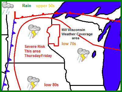
Good Rainfall chances the next few days. Strong storms possible Thursday and Friday.

Regional View.

This forecast was issued to help notify people of the severe weather chances tomorrow and Friday, this counts as the update to Thursday forecast from my last issue.

A low pressure system, with warm and cold fronts will pass through the area the next few days, bringing with it a good chance for much needed rainfall. Warm, somewhat humid conditions will set the stage for Severe thunderstorms which are possible across most of Minnesota, Wisconsin, Iowa and Illinois Thursday into Friday, as the system cold front pushed through. Cooler, showery and rainy conditions will follow on the back side of the low.

Local View.

For the local area, Most of Thursday should be dry, but it will be windy with strong SE winds near 40MPH at times, with rain chances increasing the most after noon Thursday, then rain becomes pretty likely, Some storms could be strong Thursday afternoon, and it cannot be completely ruled out that there may be a few severe storms close to the local 6 county area Thursday or Friday. Friday has a the best chance of rainfall, with thunderstorms fairly likely, Again some storms could be strong to even possible severe. This is the first real chance at Severe Thunderstorms the area has been in so far this season. We should see some pretty nice rainfall totals with this system, as it will be slow to move out bring us soak rains through the weekend. Temperatures will be fairly warm close to the 70s Thursday and Friday, it may even feel a bit more muggy. then temperatures cool off Saturday to the 60s with a chance at showers,

Thursday, Warm and Windy winds 35 to 40MPH at times, Partly Sunny then a chance of Thunderstorms in the afternoon, some storms may be strong, if not severe, highs in the low 70s. Thursday Night, a chance of showers and Thunderstorms, otherwise mostly cloudy with lows in the low 50s

Friday, Warm, Showers and Thunderstorms possible throughout the day, some could be strong or even severe, heavy rainfall possible. Highs in the low 70s. Friday Night, a chances of showers and thunderstorms otherwise mostly cloudy, with lows in the upper 40s.

Saturday, Windy, and cooler, with a chance of showers. Highs in the low 60s. Saturday Night, Mostly Cloudy with lows in the low 40s.

Looking Ahead.

at lest a snall chances if Showers may last into parts of our Sunday with this low pressures system that will be pulling in. It does looking cooler behind this system. Things dry out some for Monday, and temperatures appear to warm up to fair values. Then we got even warmer with rain chances increasing slightly again for Wednesday May 5th. Then a warm-up with dry weather the 6th-7th, then the forecast models show a strong cool front push through the 8th with a chance at rainfall, too early to tell if this will be severe or not, but it's something to watch. then I see chilly temperatures around the 9th, but the cool air doesn't look to stick around long, warm air pushes back in after this date, more on this later.


Monday, April 26, 2010

Continued sunshine, but turning warmer, then increasing rain chances towards the end of the week.


Regional View.


Canadian High Pressure will continue to bring us dry and sunny weather, with chilly temperatures for Tuesday and Tuesday Night before things warm up Wednesday as a cool front turns into a warm front and moves north. by Thursday highs will be approaching the 70s once again with increasing chances for rainfall, more in the looking ahead forecast.


Local View.

Locally, Were going to have a couple of nice sunny days area, Thursday should be clear sunshine, with chilly temperatures, but not bad, with highs in the 60s. Winds should be more calm then they were Monday. Tuesday Night will fall to the mid 30s, with some low 30s in areas of the north. Wednesday will be Warmer with sunshine and highs in the mid 60s, lows in the low 40s. Thursday will be warm with sunny skies at first, then increasing clouds ahead of a low pressure system which could bring us some rainfall Thursday night or Friday, I may have to update this forecast before Thursday, Daily forecast below.

Tuesday, Sunny and Dry, Chilly temperatures, and less wind, with highs in the low 60s. Tuesday Night Clear, Chilly, lows in the middle to lower 30s.

Wednesday, Sunny, Warmer, highs in the mid 60s. Wednesday night, Clear, lows in the low 30s.

Thursday, Sunny then increasing clouds, highs in the low 70s. Thursday night. A chance of showers and Thunderstorms, lows in the mid 40s.

Looking Ahead.

Attention in the long range forecast is turned to a low pressure system which has a good chance to finally give us some descent rainfall. Friday appears to be wet, with a chance of showers and thunderstorms. At this point it is too early to tell if things will be severe, but it will be something to watch. The rainy showery weather could last through Sunday May 2nd. Monday and Tuesday look dry, with fair temps then Wednesday a cold front passes and brings chilly temperatures for the middle of the first week of May. then it warms up quickly as we approach the weekend of 8th/9th. towards the end of the model run, It shows possible Very warm temperatures and rainfall chances. So to sum it up, it looks like a more active pattern then we have been in for the past week.

Sunday, April 25, 2010

April Showers bring, well.... & The area could still use more rain. Moderate to Severe drought across the area.

Rain covered Tulip April 25th

Well certainly not May Flowers if that's what you were thinking from the title of this post, Because we got flowers blooming now and it's still April! The northern edge of some rain bands from A area of strong low pressure well to the south of Wisconsin finally brought some much needed rain to the area, after a week of dry calm weather, light to moderate steady rain fell through much of the day Saturday, some places even had thunderstorms with heavy rainfall. Most places picked up around a quarter inch of rain, I recorded exactly 0.25" from this weekends rainfall, Which isn't drought breaking, but it really helped out.


Image from U.S Drought Monitor April 20Th image.

Even though we got some much needed rainfall, we could still use more, Moderate to Severe stage drought covers all of Northern and Western Wisconsin. and in the 6 county area Northern Dunn & Northern St Croix, Polk, Barron, Burnett and most of Washburn counties are listed in this category, Severe drought covers all of southeastern Washburn county. here at my location I've only picked up 2.77" just under 3 inches of rain this entire Spring so far, including March. and Spring is known for lots of rainfall, but this year it has been fairly dry, and this is not a good way to start of the growing & planting season. Southern St Croix and Dunn counties are completely drought free from abundant rainfall in that area last fall.

I want to mention I haven't always been the most timely with my forecasts and posts lately, Spring is a very busy time, especially for a Gardener! I've been busy planting, and cleaning and restoring parts of our yard which have not been messed with in years, and now lawn mowing starts hard to believe talking about that when it's only April!

Thursday, April 22, 2010

Tulips are in full bloom! turning out to be much earlier then last year & even more surprises!

Full view of my entire garden April 22nd,


Tulips from my former 2009 fridge project are in full bloom this week, making this the most sucessful Spring garden I ever grown. Just like Daffodils are, Tulips are extra early this year. One of the earliest I've ever recorded! in the past 3 years I've been observing Tulips in my garden, they generally were in bloom the second to 3rd week of May. including last year when Tulips were in full bloom on May 10th, This is typical bloom time for Tulips in Western Wisconsin, so it is very easy to tell were having an earlier then normal spring growth, up to as much as 3 weeks!


4 Tulips along side many yellow Daffodils April 22nd, both former fridge projects from 2009


Even though this has already been a very exciting spring for me in the garden, I am continuing to be extremely surprised at the way these Tulips from the fridge 2 winters ago are blooming. They are absolutely beautiful! When I saw these sprouting earlier in the season I was expecting maybe a tulip or 2 would flower since it is known that tulip bulbs grown in a refrigerator are severely weakened and do not bloom again, but I actually got not a decrease in number of flowers, but a significant increase! I have a total of 17 flowers from these bulbs this year, where last year I had 10 from the same number of bulbs, That's in increase by 7 flowers! The clump that had the least number of flowers last year has the most this year, and the batch that had the highest number now has the least.


A batch of a dozen Tulips April 22nd.

A couple interesting things about this particular batch of Tulips is not only the fact that there was only 4 blooms here last year, which is an increase by 6 flowers, But the color in which these are arranged. These were bought in 2 mixed bags of colors they were supposed to be colors of pinks, reds, purples and such that I mixed up and planted at random in cups before putting in the fridge in Winter of 09, I just think it's interesting how it looks like I had a plan when really I didn't! It appears like a "rainbow" of colors in waves, If you notice, from the left side of the picture to right, light orange is on the side, yellow in the middle, red in the second middle section, and darker orange on the right side! Even in the other clump in the photo above this one, there happens to be 2 reds, 2 yellows, It's interesting how things turn out sometimes!

The Tulips from my 2010 fridge project have not yet bloomed because they were planted at a later time, and the ones left in the ground really got ahead of them. I will post once those open There are supposed to be some fancy ones!

Wednesday, April 21, 2010

Very nice for end of week. Then rain chances for Saturday & Sunday, Also remider that the Statewide Torndo Drill is tomorrow. Updated X1

Regional View.
Were still looking at Pleasant and Sunny weather for the rest of the work week, with highs approaching the 70s Friday!
Then Saturday, The first chance of rain moved into the area in many days. A low pressure system and a warm from will pass by across the Upper Midwest and bring a chance for rain showers, with rain spreading Friday night into Saturday night, Some Severe Thunderstorms and heavy rain is possible across parts of Iowa, Wisconsin, Minnesota, and Illinois, and will have to be watched closely especially in the red shaded areas above. Rain showers may lasting into Sunday. Rain will make for a cooler weekend compared to Fridays highs.

Local View.

Locally we are looking at nice weather Thursday and Friday, with sunshine both days, and Highs in the 60s as 70s during the day, and lows in the upper 30s to low 40s at night,


But the high pressure system that has been giving us this nice weather will move off and bring us a chance at some much needed rainfall for the area. I did make some changes to my forecast when it comes to timing on this rain, and even added the chance for the possibility of strong storms. It is now looking like there will be a off and on chance of showers and Thunderstorms through all of the daylight hours Saturday, Although it looks like the best chances for Severe Thunderstorms and heavy rain will be south of the area, some storms could be on the strong side and may have heavy rainfall. Showers will possible we we go through Saturday night into Sunday as a low pressure system moves slowly east. Sunday will be mostly cloudy with a chance at off and of light showers. The reason for the change in my forecast is, The models moved the low pressure system with a more Northerly track then what it was showing a couple days ago, and are now hinting that some of the rainfall possibly being a bit on the heavy side with the best chance at the heaviest rain and possible thunderstorms during the afternoon Saturday, This will also be the best chance at stronger storms. rainfall amounts could to near the half inch range. Daily forecast below.


Thursday, Nice, Sunny with highs in the upper 60s. Thursday Night, Clear, lows in the upper 30s to lower 40s


Friday, Very Nice! Sunshine with highs in the lower 70s. Friday Night, Partly Cloudy, lows in the low 40s.


Saturday, Off and on showers and thunderstorms through out the day, some rain could be heavy at times, also watch for stronger storms possible, Highs in the mid 60s.


Sunday, Mostly Cloudy with a chance for off and on showers. Sunday Night, Mostly Cloudy, lows in the mid 40s.

Looking Ahead.
After this weekends rainfall things look to clear out for Monday, Mild April temperatures continue. Tuesday and Wednesday April 27th-28th the models hint at a weak systems bring a chance for light rain. Then it looks dry again for Thursday the 29th. Friday April 30th and Saturday May 1st shows a larger system bring a better chance at some rainfall, with possible some heavier amounts. Then a small system brings another chance at rainfall May 4th. then afterwards things dry back out. So all in all the long ranges charts show up and down temperatures and increasing chances for rainfall, Unknown at this times if any Severe Weather will occur with these systems.


Statewide Tornado Drill Tomorrow

The Wisconsin Statewide tornado drill as a part of Severe Weather Awareness week is set for tomorrow, Thursday, April 22nd. The Drill is to remind people that were in severe weather storm season, and to have plans in case severe weather strikes. Most communities will sound outdoor warning systems tomorrow in the afternoon. Below is a list of times siren expected.

1:00PM the NWS issues a simulated Tornado Watch for all of Wisconsin.

1:40PM-1:45PM the NWS in the Twin Cities will issued a simulated Tornado Warning for Polk, Barron, St Croix and Dunn Counties. Most communities will sound their tornado sirens for about 3-5 minutes at this time.

1:50PM-1:55PM the NWS in Duluth,MN issues a simulated Tornado Warning for Burnett and Washburn counties. Most communities will sound there tornado sirens for about 3-5 minutes during this time.