Severe storms with high winds and large hail impacted parts of the area Wednesday July 18th. The areas most impacted were Dodge, Mower and Fillmore counties. The cause of the storms was an eastward moving boundary into a very warm unstable airmass. A cell that developed in Central Dodge County near Dodge Center quickly became severe and pushed southeast into southern parts of the county. The first reported severe weather was from the Hayfield area reported hail to the size of 1.50" This is the second time this month Hayfield was hit with a significant storm. The storm continued pushing southeast into Mower and Fillmore counties, where it turned mainly into a high wind event. Wind damage was reported around Spring Valley with multiple trees down as well as minor structural damage from wind. The storm continued enveloping southeast into Iowa where it turned into a very severe wind producing squall line. On a brighter note. Severe drought stricken areas in the south received around 0.50 to 1.00" of rain from this same storm.
Severe Storm Reports
Hayfield 1.50" Hail
Spring Valley Tree branches down. Damage to park pavilion and apartment building.
Other Reports
Dexter 0.88" hail
1 mile W Grand Meadow 50MPH gust
1 mile S Racine 50MPH with 0.50" hail
Preston Airport 49MPH wind gust
Harmony 53MPH wind gust.
Photo1


Iowa Weather Network Warnings Map

Thursday, July 19, 2012


Saturday, July 14, 2012
Extreame Heat returns to the area heading our way for Monday Highs approaching the upper 90s to 100.F Monday and Tuesday with heat index values around 110.F next 3 days. Tuesday is our next chance for rain.

Extreme heat which is becoming the fairly common wording in Upper Midwestern forecasts this summer is heading back to the region to end out this week and to start off next week. Record heat is possible with Highs approaching or hitting 100.F is expected to be widespread across South Dakota, Southern Minnesota, Iowa, Illinois and Southern Wisconsin, which is a rarity in areas this far north. Scattered thunderstorms are possible near the cold front as it moves south on Tuesday and Wednesday.

 Local and Metro views.
We can expect a very hot and dry ending to the weekend and to start off the next work week as an extremely hot air mass in the west slides in from the west Sunday. For the next 3 days high temperatures will be above 90.F. Sunday in our local area will feature sunny skies and it will be humid. High temperatures will be in the low to middle 90s with heat index values in the middle to upper 90s. Lows will be in the middle to upper 70s
Short lived Extreme Heat Expected Monday/Tuesday
The heat really peaks off Monday and Tuesday in our local area as the very hot and humid air mass settles into our region. This will be the type of airmass where airmass makes little difference on how it feels becuase heat index values will be between 99 and 110.F during the day and barely got below 80.F at night. Air temperatures under sunny skies temperatures will soar well into the 90s with widespread upper 90s likely and a few isolated areas/hot spots hitting 100.F Areas with the best chance of hitting 100.F will be river valley cities like Red Wing and Winona as well as the urban and Downtown areas of Rochester. Tuesday may be slightly cooler but highs will still be around 95, nearing 100.F Lows both nights will be 75 to 80.F. This extreme heat will be a short lived but it should still be taken seriously becuase heat of this magnitude can be dangerous.
Small threat for rain Tuesday
Tuesday night a cold front will slide across the region producing the chance for scattered thunderstorms in our local area. This chance at rainfall is not extremely high at this time and not all areas will get wet. Amounts will range to around 0.25" with possible higher amounts. Temps will cool off only slightly behind this front as skies become sunny again and things dry out, highs will be around 85.F
Sunday, Very Hot! and very humid. Heat index values approaching 100.F Sunny skies. Highs in the lower 90s to mid 90s urban Rochester. Sunday Night, Clear skies, lows in the middle 70s.
Monday, Extreme Heat! and humid. Heat index values approaching 110.F Sunny skies with southwesterly winds around 25MPH. Highs in the upper 90s to lower 100s. Monday Night, Clear skies lows in the mid to upper 70s.
Tuesday, Extreme Heat! and humid. A chance for thunderstorms late. Heat index values approaching 105.F Sunny skies with highs in the mid to upper 90s. Tuesday Night, a chance of thunderstorms, otherwise partly cloudy with lows in the upper 60s to lower 70s.
Wednesday, Sunny and very warm. Highs in the mid to upper 80s. Wednesday Night, partly cloudy lows in the mid to upper 60s.
Thursday, Sunny and very warm. Highs in the upper 80s. Thursday Night, clear skies, lows near 70.F
Looking Ahead
It doesn't stay "cool" for long if you can call it cool. Already by next weekend we will be dealing with highs back into the lower to middle 90s Friday and again late Saturday into Sunday may offer a chance for rain for us. Then Tuesday July 24th the model brings in a fairly strong cold front bringing the chance for rain, possibly heavy? then cooling us down and drying us out for the weekend of July 27th After this date, heat builds back west once again. And the threat for rain every few days remains.
Friday, July 13, 2012
Strong to Severe storms effect parts of the area. High Winds, Hail, Heavy Rains/minor flooding.

Strong to severe storms effected the area today. Hail, High winds and heavy rains causing flooding were all the main effects with these storms. The cause of the storms were from several boundries throughout the area. After things became unstable with afternoon sun the boundries were all that was needed for storms formed on these boundries. Some of the storms developed and became severe. The strongest storms produced 60MPH winds in Southern Dodge County at Hayfield. Another cluster of storms effected Goodhue, Olmstead and Mower Counties. In the Rochester metro area, heavy rain, gusty winds and a little bit of small hail was seen. Rochester Northwest side has wind reports of 50MPH with winds slowing down to 21MPH at the Downtown wind station. At my station for rainfall 0.76" of very benefical rain fell at my station brining the dayily total from morning storms to 1.02" breaking a 22 day in a row dry streak. Several other areas also reviced benefical rains including drought stricken areas in the southern part of the area. In some cases rainfall was even excessive. Southern Dodge county reported minor flooding with radar estimates coming in around 3 inches between Hayfield and Kasson. The highest reported rain ammounts was Hayfield at 1.30"
Storm Reports
Severe reports
Hayfield 60MPH
Hayfield Heavy Rain 1.30" minor flooding in southern Dodge county.
Other reports
Northwest Rochester 50MPH wind gust.
West Downtown Rochester pea sized hail
Claremont pea sized hail
Kasson pea sized hail
Sunday, July 8, 2012
Plenty of sun. Very warm and dry week ahead turning hot in the 90s by midweek. No rain chances anytime soon.

A very quiet week in the Upper Midwest as a high pressure system takes control of the weather, there will be very little chances for rain. Temperatures will start off near seasonable but they will increase a the week goes on and it likely turning hot by mid week, but not nearly as hot as least weeks extreme heat wave.


Local and metro views.
Locally it we are staring right into a very dry and very warm week ahead. Unfortunately there is no rain in sight at this time as a large area of high pressure will give us at least 5 days or so of sunny weather. We can expect everyday to have sunshine and near seasonable temperatures with starting off in the low to mid 80s and lows in the mid 60s on Tuesday and Wednesday, then Thursday we will go back into kind of a hot spell, although not nearly as hot as last week heat wave it is likely temperatures will rise to the middle to upper 80s, with some 90s appearing in inner city Rochester and hot spots. Lows will be in the middle to upper 60s. It look like after we enter this hot spell to remain very warm to hot through next weekend.
Monday, Sunny and warm. Light winds with highs in the lower to middle 80s. Monday Night, Clear skies lows in the lower to middle 60s.
Tuesday, Sunny and warm. Light winds with highs in the lower to middle 80s. Tuesday Night, Clear skies lows in the lower to middle 60s.
Wednesday, Sunny and very warm. Light winds with highs in the mid to upper 80s. Wednesday Night, Clear skies, lows in the middle to upper 60s
Thursday, Sunny and hot, light winds, highs in the upper 80s to lower 90s. Thursday Night, Clear skies lows in the lower to middle 60s.
Friday, Sunny and hot, light winds, highs in the upper 80s to lower 90s. Friday Night, Clear skies lows in the lower to middle 60s.
Looking Ahead
Looking into the weekend Saturday and Sunday look dry and partly cloudy and very warm to hot temps. Highs will probably be close to 90. Our next decent chance of rain will be Monday July 16th as cold front passes through and a weather system passes through Minnesota. It turns drier and hot again by Wednesday the 18th and remains fairly dry and hot through Monday the 23rd of July.
Friday, July 6, 2012
June 30th to July 6th Sigificant Heat Wave Report. Records broken with a very long streach of 90+ degree weather peaking out into triple digit numbers July 4th and Friday July 6th! Longest heat wave in years.


Hot red glowing sunset Rochester,MN July 2nd 2012
Locally this heat wave was a significant one and one for the record books at Rochester airport. This heat wave was the worst one in a number of years according to many as we sweltered in heat for a week. It was certainly the warmest and longest I've delt with. From June 30th through July 6th every day was above 90.F in all areas and a couple days were in the upper 90s to lower 100s, with heat index values every day in all areas well into the 100 degree range, as dew points straddled each day from the low 70s to nearly 80.F! 2 of our official stations, Red Wing and Winona went above 100.F 2 of the days, This is the first time in many years that a heat wave has brought more then 1 day of 100 degree temperatures. At my location all days were well into the 90s and 2 of the days ended up being at or above 100., July 4th the high was 100.F, but the warmest high temperature was 102.F on July 6th. This is the warmest temperature that I've experienced personally, before that it was 100.F in my hometown in NW Wisconsin which occurred in June of last year. I felt all 102 degrees of it and takes a toll fast. There was no relief at night either the warmest low at my station was 80.F on July 4th and again July 6th. During the evening of July 5th before I went to bed at 11:30pm the temperature was still 86.F which was stunning to be becuase I have not seen heat last this long into the night before. Effects of the very high temperatures caused power companies across some areas to ask residents to keep power usage to a minimal during the height of the afternoon hours. You could also see the effects of very warm temps and lack of rain taking a toll in our landscaping most people have had to water plants every day just to keep them from wilting. Unwatered lawns have been completely parched espesscailly in sites with poor soil and lots of sun. Corn crops are started to wilt from lack of rain and very high temperatures.

The highest official temperature during this heat wave came from Winona and Red Wing which both reported extreme heat of 102.F with heat index values of 109 and 111! I found it rather interesting that northerly stations were the warmest throughout the area. My theory in why these areas are warmer is because there river valley cities in low warm valleys. In the Rochester Metro area Downtown heat island effected weather stations were between 99 to 102.F. My station was 102.F. This brings the yearly total days at 90 or above to 18 and the days at or above 100 to 2 days. Officially the highest temperature at our cities official weather station at Rochester International Airport was 96.F and no 100s occurred. The records that occurred at the airport were several daily low temperature records. The difference in temps between Downtown and the Airport has been an ongoing study for me but theory on why Downtown areas of Rochester are so much warmer then the airport is because of how the city also sits in a river Vally but it is also becuase of the high concentration of large buildings and concrete forming a heat island effect. I did call NWS officials at both at Chanhassen and La Crosse and they confirmed the same theory on why there is a difference.
Tuesday, July 3, 2012
Dangerous long lived Heat Wave Expected All time highest records in jepordy with highs in the lower to middle 100s Heat Index Values between 110 and 115.F
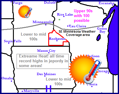
Regional Weather View.
The top story in the Upper Midwest continues to be an ongoing dangerous heat wave! A very stubborn high pressure seen south of where it is shown will continue to create a long live heat wave for the entire region. triple digits heat is expected for the next few days for cities in Minnesota, Wisconsin, Northern Iowa and South Dakota, While Southern Iowa, Nebraska, Missouri and Illinois will be baked with the same heat going over 100.F for this same time frame. Very little rain will be seen across the region with only a slight chance of isolated thunderstorms neat the warm front.

 Dangerous long lived heat wave likely! Triple digit heat over the next few days, Record highs likely!
The area will be under the influence of a full fledged and dangerous long lived heat wave for the rest of the week. We can expect Every day will feature sunny skies with hot to very hot/very humid conditions! We can expected high temperatures to be at or above triple digit levels with low to mid 100s for the next 6 days with urban areas of Rochester seeing highs above 101.F every day and having the chance to see highs around 105.F on Thursday The highest all time record for Rochester Airport is 105.F, we will see temperatures approach value. Finally, With dew points expected in the upper 70s we can expect extreme heat index values will be between 110 and 120 each day. There will little relief at night as lows stay around 75.F. People should be aware this is a dangerous and life threatening heat wave if not taken seriously! Prepare yourselves for an usually long lived time frame of hot weather. Heat like what is expected can be dangerous if not taken seriously and people in our area are not used to be prone to heat this long lasting. Drink plenty of water, Try to wear light colors, Be in shade or stay in air conditioning as much as possible.
4th of July Weather!
For the Independence Day Holiday Expect it to be hot, humid and sunny with highs in the lower to middle 100s and heat index values around 110 to 115. It could be dry for fireworks with lows in the mid to upper 70s! Have a great holiday!
Tuesday, Extreme Heat! Sunny and Humid! Highs in the upper 90s to low 100s Urbanized Rochester. Heat Index Values around 110 to 115.F Tuesday Night, Clear Skies, Hot, Lows in the mid to upper 70s
Independence Day! Extreme Heat! All time record highs possible, Sunny and Humid! Highs in the low 100s to middle 100s Urbanized Rochester. Heat Index Values between 110-115.F Wednesday Night, Clear Skies, Hot! Lows in the mid to upper 70s
Thursday,Extreme Heat! All time record highs possible Sunny and Humid! Highs in the low to middle 100s with middle 100s Urbanized Rochester. Heat Index Values around 110 to 115.F Thursday Night, Clear Skies, Hot, Lows in the mid to upper 70s.
Friday, Extreme Heat! Sunny and humid with highs approaching 100.F Heat index values around 110 to 115.F Friday Night, Clear skies, Hot lows in the mid to upper 70s.
Looking Ahead
Saturday a cool front passes cooling it down and bringing the chance for thunderstorms. Sunday looks sunny and seasonable. Then around Tuesday the 10th the models begin to turn things active with the possible threat for heavy rains. It remains stormy and cooler through Saturday the 14th, with the threat for rain every couple days or so. Towards the end of the model run it begins to build heat again to the west, and it turns things drier and warmer for us.
Sunday, July 1, 2012
Threat of severe weather today.

The SPC has issued a Slight Risk for Southern Minnesota and Wisconsin as well as Northeast Iowa. This includes most of the local area. To view the SPC Discussion go HERE
Local Discussion, A warm front that will bring even more heat and humidity into our region will move through the area today. Thunderstorms could develop along the warm front but the question is when will they form and how strong will they become. Some models show the threat of severe weather isolated and quite low today, while others develop a line of storms in Northern Iowa and move them Northeast effecting most of the local area, which has to be considered for possibly happening. If storms develop and the right conditions come together, we can expect the main threats to be high winds, heavy rain, large and at as the storms 1st develop tornados. Residents should keep in mind there is a severe weather risk today! Stay near a weather radio or other outlet at all times!
Subscribe to:
Posts (Atom)