Map Image Legend Image

Iowa Weather Network Warnings Map

Iowa Weather Network Warnings Map

Winter Weather Advisory

Friday, March 16, 2012

Historic Record Warmth- Summer in March 1st 80s of the season! Warmth brings on the 1st Daffodil blooms of the season!

Budding out Elm Trees March 16th 2012

Stunning, Weird, Wild, Beautiful, Awesome are all words that can be used to describe this extremely nice weather we've been having this week. A record setting March heat wave has been impacting the region since Tuesday, and since that day highs have easily reached the 70s, and today some places hit 80s for the 1st time this season. People were out wearing shorts and short sleeves on what was actually a hot and relativity humid day even before calender Spring, which is extremely rare and unheard of this early in March. Temperatures today were at least 40 degrees above average. I was outdoors all day and drinking lots of water was needed to stay cool.

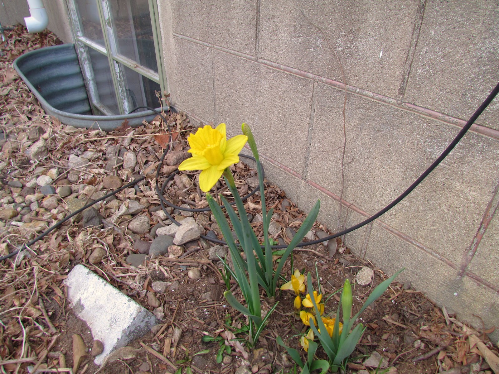
Daffodil bloom March 16th 2012

It is hard to keep up with Spring growth reports when all the plants and trees are progressing fast then I have ever witnessed! Last week I was talking Crocus and Snowdrop, now today the 1st Daffodil blooms of the season are being seen and it wont be long before there in full bloom. This is definitely with out a dought the earliest Daffodil bloom I've seen. I've also now noticed Tulips buds are above ground, almost all the trees are showing signs of budding out and bloom and lastly the grass is quickly turning green!

Highs Friday

Everyone was quite warm well into the 70s. Average high is 45.F and low is 26.F The warmest official airport temperature reported was in Red Wing and Winona both at 81.F The Rochester Metro has the warmest temp un officially with 82.F.

Monday, March 12, 2012

Stunning weather ahead! Very warm almost Summer-like week forecasted with record breaking temps most days this weeks. Near 80 tomarrow! Updated X1

Regional weather view.

Record Warmth! That is the big story across the Midwest this week. A fully entrenched warm pattern has engulfed the entire U.S and is going to spread Summer-like warmth into Minnesota and Wisconsin. Temperatures as warm as the 70s to 80.F ispossible as far north as Southern Minnesota and Western Wisconsin. With mid 80s in Iowa. This week will just be a dry, and very warm week.


Regional and Local weather views.

 Stunning week ahead-Record Temperatures everyday!

 
This is going to be a stunning week in the local area with record warmth likely everyday. It will feel very Summer-like and nothing like March as our average high is about 45.F and our lows will not even be anywhere near this! Each and every day this week through Sunday and even into next week will be in the 70s, but for the forecasted time frame it will feature sunny skies with temperatures at or above 70.F with lows in the 50s, in some causes lows will be as warm as the mid 50s. Wednesday will be the warmest day following closely by Thursday Highs will be in the upper 70s, near 80 in most areas Wedneday, and I would not be shocked to see inner city Rochester stations hit the 80 degree mark. There will be no rain to speak of through Friday, just a stunningly beautiful week, hopefully many will make the extra time in the evening to go outdoors!


Wednesday, Very Warm! and Very Nice! Record highs likely. Sunny with highs in the upper 70s with low 80s possible inner city Rochester. Wednesday Night, Very Mild, Clear with lows in the low 50s.

Thursday, Very Warm and Very Nice! Record highs likely. Sunny with highs in the mid 70s. Thursday Night, Very mild clear with lows in the mid 50s.

Friday, Very Warm and Very Nice! Record highs likely. Sunny with highs in the mid 70s. Friday Night, Very Mild, Clear with lows in the upper 50s.

Looking Ahead Very warm temperatures continue into the weekend with the threat for thunderstorms late next weekend.

For those wondering if the warmth will continue into the weekend, your in luck! Both weekend days should feature temperatures in the 70s There is a small chance at some thunderstorm activity Saturday Night and Sunday but at this time it looks minimal. The 70+ degree weather will last into Monday of next week, Then moving onto Tuesday looks to have a chance of a thunderstorm outbreak. Heavy rains and the potential for severe weather would certainly be possible. It cools off slightly for the following weekend but it still looks more on the mild side. The models hold onto mild weather with another chances at showers as we approach near the end of March.

Sunday, March 11, 2012

Spring Growth Update #1 Snow Crocus and Snowdrops in Full bloom, Early flowering trees blooming!

Blooms of Sliver Maple March 11th 2012

The calender may say winter, but the signs of spring are everywhere. This is an exciting time of year for Gardeners and I like to follow spring through to leaf out and with this weeks weather were well on our way! A beautiful weekend in the upper 60s with sunshine has lead to early spring growth to start weeks ahead of schedule! Southern Minnesota is not normally seeing sigificant growth until the second to last week of March. With a morning low of 42.F and a high today of 66.F it was a perfect day to get out and take pictures. Above are Silver Maple blooms, not many people take the time to notice them much as they have to petals becuase there a wind pollinated bloom and are not showy, but they certainly add a sweetness to the air before they become a nusinces and drop seeds everywhere later in the year!
Yellow Snow Crocus March 8th 2012

The snow crocus are in full bloom now and came into full bloom just in time for my 21st birthday! It was quite a nice surprise. I took this photo last Thursday and I did note to myself that this is the 1st time I seen Crocus blooming in time for my Birthday.


Full garden view. March 11th 2012

This is the full garden view I took today. Right now Snow Crocus are the only blooms I have, I planted more crocus in colors of Purple and White but I'm still waiting for those to bloom, they bloom about a week later then the yellow, so I suspect I should be seeing those soon. Daffodils are about 4 inches tall with flower buds well out of the ground, Hyaciths also have flower buds starting to rise, and lastly the Tulips have 1st leaves well out and their well on there way to growing.

 Area Snowdrops March 11th 2012

Walking around old neighborhoods in the city I could see snowdrops in bloom! This is the first time I've ever seen snowdrops in person, and I had not known they were so small! I've tried them in my Wisconsin garden but they did not work out for me. Next fall I may have to try these again!

Thursday, March 8, 2012

Warming trend for the weekend, 60s by Saturday! Increasing chances for rainshowers late Sunday into Monday. 70s possible next week!

Regional Weather View.

Continued Warmth will be  the main story across the Upper Midwest through Saturday. A warming trend will bring 50s and 60s back region wide, which will continue to depelete the snowpack across the north. Sunday and Monday a low pressure system will spread clouds and rainshowers across Iowa, Eastern Minnesota and Wiscoinsin. It will be warm enough that most of this will fall as rain.

Regional and Metro view.

Friday, Monderate tempetures will start on a warming trend which begin with sunny skies and highs in the mid 40s Friday, lows in the low 30s.

Beautiful Saturday!

A warm front will pass through the area and bring on a sigificant warm up for Saturday and bringing the area a beautiful day. Under sunny skies, highs around 60.F are likely with lows in the upper 30s, Winds will be a bit breezy from the south, but it will be a warm wind, gusting to 25MPH at times. People should go outdoors to enjoy Saturday because Sunday it will begin to cloud up.

Rainshowers developing later Sunday

 Most of the day Sunday will br dry with highs in the mid 50s, but during the evening and overnight showers will begin developing, some could be on the moderate side, but heavy rain is not expected. Lows will be in the mid 40s Sunday Night. Monday will be cloudy with showers espessially early, some thunder is possible, with highs in the upper 50s and lows in the 40s. Rainfall are questionible at this time but up to a quarter inch is possible.

Friday, Mild, Suny and Nice! Highs in the mid 40s. Friday Night, Clear skies, lows in the low 30s.

Saturday, Much warmer and Breezy, Very Nice! Sunny with highs in the low 60s. South winds to 25MPH Saturday Night, Mild, Partly cloudy with lows in the mid 40s.

Sunday, Increasing clouds, light rain developing late. Highs in the mid 50s. Sunday Night, A good chance of rain, could be moderate at times with thunder possible. Lows in the low 40s.

Monday, A chance of rain early then mostly cloudy. Highs in the upper 50s. Monday Night, Partly Cloudy lows in the low 40s.

Looking Ahead Spring-like Warmth Continues!!! 70s possible next week!

Sunday and Mondays rain will set the stage for a beautiful spring like week! It will be dry and sunny most of next week, Sunshine looks likely most days with 60s almost likely every day through Friday, there is even a chance that 70.F degree tempetures may be reached around midweek! The dry, beautiful weather will last through Friday. Next weekend a strong cold front and storm system will bring a threat for thunderstorms and heavy rain. This weather system could bring the threat for Severe thunderstorms to the local area on Sunday the 18th and a few days after, The models are keeping it very week each day through the 22nd with every other day having the threat for heavy rain and thunderstorms. The weekend of the 23rd looks to dry out with a breaif cooldown, before it warms up for the weekend. More on this later.

Tuesday, March 6, 2012

Beautiful day today- Very warm temperatures well into the 60s, some spots hit 65 today! Crocus Picture included.

Blue skies during a beautiful mild day contrast Downtown Rochester March 6th 2012

Today was a stunningly beautiful day across the local area, featuring crystal clear skies with highs at every station well into the 60s, not a record breaker, but at least 25 to 30 degrees above normal! The cause of the warmth is a well above normal air mass that has enveloped most of the Upper Midwest from a warm front which past through Southern Minnesota last night. The wind was a bit stiff out of the Southwest gusting to 30MPH at times but it was a warm wind for sure. The warm temperatures brought many outdoors in shorts and short sleeves as it felt very spring like feeling more like April then March, I was able to take a walk today without a coat, and I have not been able to say that very often so early in March. I did see my first bees today buzzing around during class which took place outdoors today!

Yellow snow crocus open up wide on a warm sunny March day March 6th 2012

The spring bulbs progressed much faster today and got a good head start in the warmth that allowed them to. Daffodils and Hyacinths are showing flower buds and Tulips are getting 1st leaves and turning red.  The yellow Snow Crocus are approaching full bloom and the Dutch crocus I planted which are in colors of purple and white should be showing soon as its normal for them to bloom about a week after Snow Crocus. All these spring bulbs certainly extremely early. It is unheard of to me and are by far the earliest I've seen blooming Crocus, in all my years of gardening I cannot recall even 1 time when Crocus bloomed before my March 8th birthday, but my new southerly latitude much be taken into account, but even locals agree its about 3 weeks early.

Highs reported.

All stations were above 60.F The warmest official temperature was Preston at 64.F The warmest temperature over was in inner city Rochester with a high of 65.F

Sunday, March 4, 2012

Very Beautiful and breezy start to the week. 40s Mon, then sigificant warm to the 60s Tuesday! A chance of rainshowers Wednesday, but nice again by Thursday.

Regional weather view.

The huge story making news in the Upper Midwest this week is no longer a chance for snowstorms, but a significant warm up that will bring very mild spring like weather to the region. A strong warm up will bring 60s as far north as Southern Minnesota, 50s as far north as snowcovered areas of Northern WI and MN and 70s as close as Southern Iowa. A cool front will bring the threat for rainshowers Wednesday, before it clears out and stays mild for the region Thursday.

Local and Metro views.

A stunningly beautiful week ahead for the local area, a significant warm up is in store as a strong warm front brings in mild air from the southwest. Monday will be the start of this mild pattern. Winds tomorrow will change southwesterly and be breezy gusting to 30MPH.  It will be sunny and much warmer with highs in the 40s. Lows will fall only the the low 30s. Tuesday will be our warmest day in the next 4 as high will be 30 degrees above normal as uur significant warm up peaks out under sunny skies and breezy southwest winds. With no snowcover I see no reason why most places wont at least reach 60.F, with a few spots getting slightly above that! Lows will actually be what our normal highs should be in the low 40s. Wednesday will be partly sunny and not as breezy, highs will be in the middle 40s, but a weak cool front will slide into the state bringing a chance for light rain showers in the afternoon and evening. about a 10th of an inch or so is possible, but It will be a quick moving system and out of our hair by Thursday Morning. Thursday Sunny skies come back into the picture with highs in the mid to upper 40s. and lows in the upper 20s

Monday, Much Warmer, Breezy southwest winds up to 30MPH. Mostly sunny with highs in the low 40s Monday Night, Partly Cloudy, lows in the low 30s.

Tuesday, Very Mild and Nice! Breezy with southwest winds to 35MPH Sunny and warm with highs in the low 60s. Tuesday Night, Very Mild! Partly cloudy with lows in the low to mid 40s.

Wednesday, Partly Cloudy with increasing clouds and a chance of rainshowers late. Highs in the mid 40s. Wednesday Night, A chance of rain, cooler with lows in the upper 20s.

Thursday, Clearing skies and nice! Sunny with highs in the mid 40s. Thursday Night, Clear skies, lows in the mid 20s.

Looking Ahead

    Spring has begun? It sure looks like in in the models becuase I see nothing but warmth and dry weather! Next weekend looks very mild and sunny, I'm sure 50s would be likely. Starting in the week of the 12th all the way through the 16th continues to look very warm, but it stays dry through the entire time. A few days in the week between the 12th and the 16th has the chance to flirt with 70s here in Southern Minnesota! Then on Saturday the 16th the models show a cool front bringing rain showers and a brief cool down before it warms back up around the 20th. All in all a very warm extended forecast.

Thursday, March 1, 2012

Cooler weather this weekend with some chances at light snows. Light amounts only. Then looking towards a sigificant warm up next week, 50s for sure!

Regional Weather View.

Atteintion in the Upper Midwest is turning to the eastern part where another strong dynamic storm system will bring heavy snows in Eastern Wisconsin where sigificant snow is possible. Heavy rain and thunderstorms even severe weaher is possible in Illnoise which could cause quite a few issues. Further west a cold front will follow this storm brining the changes for light snows extending back into Iowa and Minnesota. A sigificant warm up will take place starting early next week when warm air will be forced into the region from the west.


Local and Metro views.

Locally we can expect a cooler weekend ahead with the threat for off and on light snows. Friday will be mild but dreary with plent of clouds, highs will be in the upper 30s with lows in the mid 20s. Saturday will be breezy and much cooler, The threat of light snow will continue. All this snow will be under an inch and will not cause issueds can could even melt on contact. Highs will be in the 30s on Saturday, with gusty winds to 30MPH at times making for a cool wind chill. Lows cool to the 10s Saturday Night. Sunday will be a bit warmer and less windy. Under partly sunny skies, highs will be in the mid 30s with lows in the low 20s. Monday will be the start of a beautiful patter, It will be sunny and bright with highs in the low 40s and lows in the upper 20s. More on the sigificant warm up thats in store can be found below.

Friday, A chance of light snow otherwise cloudy with highs in the upper 30s. Friday Night,  Cloudy skies lows in the low 20s.

Saturday, Breezy and chilly, Cloudy with a chance of light snows. Accumulations 1" or less. Highs in the low 30s Winds could gust to 30MPH. Saturday Night, Cloudy skies breezy with lows in the upper 10s.

Sunday, Sunday a bit warmer, Partly Sunny skies with highs in the mid 30s. Sunday Night, Partly Cloudy with lows in the upper 10s.

Monday, Much nicer! Sunny skies and mild with highs in the low 40s. Monday Night, Clear skies with lows in the upper 20s


Looking Ahead Spring ahead? Sigificant warm up next week most of next week in the 50s!

A very beautiful week is expected next week as warm but dry air surges in from the west brining very mild and spring-like sunny weather. This warm up will come in quite fast as we could be enjoying highs as warm as near 60.F as early as Tuesday! Warm air will completely ingulf the Upper Midwest and remain that way through all of next week which means most days will be spent in the 50s. There is a chance of rain showers with a coo front on Friday, The weekend of the 10th looks dry and mild on Saturday before Sunday the 12th gets a bit more interesting, the model shows a chance for thunderstorms and heavy rain. It driest out with no cold air to be found behind that system. There could be another chance of rain on the 16th, then it looks like continue mild into the 17th. The looks to be a season changing pattern setting up, but only time will tell what our weather does after this warm up