Map Image Legend Image

Iowa Weather Network Warnings Map

Iowa Weather Network Warnings Map

Winter Weather Advisory

Saturday, October 9, 2010

Weekend very warm temp report, record highs broken.

Warmth October 8Th

A very mild air mass surged in behind a huge high pressure system that has been keeping us dry for the past week. High temperatures soared up to 20 degrees the normal highs of the Lower 60s. 80s were common across much of the local area, breaking record high temperatures in some places, Some Southwesterly locations even recorded Mid 80s for highs, Shorts and short sleeves were common on people this weekend, a rare site on a mid October day!

The warm streak actually started back on the 5th when highs started bumping into the 70s, the days kept getting progressively warmer as the week went on. My station reported a high 0f 82.F Friday, and a high of 82.F Saturday. This goes down as the latest 80s degree highs I've recorded at the 1st October I've recorded with 80s for highs. My low was 54 for Friday and 55 for Saturday, which is closer to what our highs should be! and the sun makes it feel actually quite warm, and a slight haze could be seen, making it feel more summer-like then fall!
The warmest high was 86.F which was reported in River Falls and Hudson. The coolest high was 78.F reported in Spooner.

Thursday, October 7, 2010

Very mild and very pleasent weekend ahead, some spots could see 80s!

Regional View.

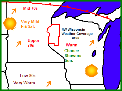
A very pleasant weekend if fore casted for the Upper Midwest this weekend, with very mild high temperatures in the 70s and 80s, it will be sunny with dry weather continuing. Sunday a few showers will roll into the picture.

Local View

Locally we can expect a very nice weekend ahead, with plenty of sunshine and mild temperatures, highs could be near if to surpassing 80 Friday or Saturday, Which is almost unheard of in Wisconsin during Mid October. People will want to take advantage of the weather this weekend. A very interesting note is last year on the same weekend in October, I was talking about highs in the mid 30s, and we had 3 inches of snow on the 10th!

Friday will be the start of the nice weekend with sun and highs in the upper 70s, lows will only fall to very mild near 60, Saturday will be the warmest of the 3 with mostly sunny skies and highs in the 70s, I would not be surprised to see a few 80s around the map which is way above the average high of about 60. Saturday Night will be partly cloudy and it will cool off to the mid 50s Sunday we have a slight chance at a shower or thunderstorm with a weak system and cool front moving through, highs should still make mid 70s it will start to cool off Sunday Night with lows in the low 50s

With a beautiful weekend forecasted, this is a good weekend to plan fall color tours in Central and Southern areas of my 6 county area, some nice color can still be found in areas of the north but not as nice as the south.

Friday, Very Nice, Sunny with highs in the upper 70s Friday Night, Partly Cloudy lows near 60

Saturday, Very Nice, Partly Cloudy and Warm, highs in the upper 70s to low 80s. Saturday Night, Partly Cloudy lows in the upper 50s

Sunday, A chance of a shower or thunderstorm. highs in the mid 70s. Sunday Night a chance of a shower early then partly cloudy, lows in the low 50s

Looking Ahead

The starting of next week looks cooler with a small chance of a shower Monday, A stronger cold front moves through Tuesday bringing with it a chance of a shower, it may even be cold enough to produce some light snow near the Canadian border. by Thursday the 14th it drys out and remains on the cool side, it warms up for a short time the 16th, then Monday the 18th we have a chance of showers with cool temperatures then on October 20th, the models are showing an interesting system being down very cold air, it this time, it could produce snow as far south as the local area, with highs at or below 32.F and lows well into the 20s It remains on the very chilly side through the rest of the model run. More on this later.

Fall Color Report # 6 Peak to High color all areas & Peak fall color pictures around my area

Fall Color Report #6

Fall color has reached peak, or is near peak at all locations in the local area. Central and Southern areas have the highest color at this time with abundant colors showing across the landscape. Northern area trees are loosing leaves fast and this area has now past peak, but nice colors can still be seen. Minog and Spooner reports past peak color, Grantsburg is still holding on to peak color but I feel they will past peak very soon. Frederic and Rice Lake are still at peak. Peak color is now being reached at my location and High color is now being reported from Menomoie and Hudson. With very mild and sunny weather forested for this weekend, it will be a great opportunity to enjoy the fall colors in Central and southern areas, The bluffs of Glenwood City to Menomonie is especially known for it's fall color beauty.


Cornfield with a forest of Oaks and poplar in the back round

I am now officially reporting Peak Color 100% at my location, the trees continue to amaze me in just how quickly they turned. All trees have shown color or are currently showing color. Sugar Maples that still have leaves are beautiful shades of yellow, Oak types have turned very nice shades of browns, reds and oranges, Red Maple has been very nice this year in spots, ranging from fire red to yellow, and Poplar and birch trees have turned shades of gold. In my yard, both ash trees are now completely bare, or are nearly bare, the 4 oaks have turned brown and dark red, the Red Maple has past it's peak and is starting to loose leaves. There are only 4 tree types left in my yard that are still green, including Apricot, Apple, Lilac, and Willows.


Fall color near my house October 6th


I went out on a beautifully mild October afternoon to take these pictures, it was sunny the wind was calm with a high of 70 at my location, It's hard to beat that in mid October!


Understory Sugar Maples in the woods south of my house Oct 6th


Fall landscapes of Clayton,WI

Fall color this year is much better then is was last year when we had early hard freezes that killed our chances at nice color. Summer was very how and quite wet. We had above normal preip for June, July, August and September, September was especially we. Then October came with with dry and fairly mild weather. I've had 2 frosts one where I reached a low of 35.F and another when I reaches a low of 31.F


Monday, October 4, 2010

Nice mild and sunny weather continues next 3 days.

Regional View


A mild and dry air mass continues to sit over the Upper Midwest bringing lots of sunshine and warmth, much warmer then the past couple nights have been. Thursday a dry cold front will pass through bringing a bit cooler weather.


Local View

Locally the forecast continues to being great news for area farmers, It looks sunny dry with very nice warm temperatures, The forecast looks great, even a bit on the mild side for October, Tuesday will be beautiful with highs in the upper 60s, lows will be in the 40s again and not in the 30s where they have been like they have Sunday and Mondays nights. Wednesday will be sunny once again and much of the same with temps in the upper 60s, A dry cool Frost will pass through late Wednesday dropping our lows in the low 40s, a few spots in the Northern areas may see temps in the upper 30s again with some frost possible. Thursday will be a bit cooler as a result of the cool front with highs in the mid 60s, which is closer to normal, It should turn out to be another very nice day with sunny skies, lows back into the 40s for Thursday Night.

The weather is expected to be perfect for fall color foliage viewing, Central areas will be the place to be this week, where this area will likely be peaking in color this week! People wanted to view colors in the southern areas should plan for next weekend, when this area will likely be peaking or near peak by that time.

Tuesday, Sunny skies Mild, highs in the upper 60s Tuesday Night Clear, lows in the mid 40s

Wednesday, Sunny Skies with Mild temps, highs in the upper 60s Wednesday Night, Clear lows in the low 40s,

Thursday, A bit cooler, Partly Cloudy Skies, Highs in the mid 60s Thursday Night, Clear Skies, lows in the low 40s upper 30s possible north where some frost is possible.

Looking Ahead

Dry, Mild and Beautiful are 3 words that sames up what I'm seeing in the forecast for quite a few days ahead, A huge high pressure system will continue to bring sunny, mild, weather conditions Next weekend looks especially sunny, mild and nice. We could be having highs as warm as the mid 70s! The models continue putting us in a dry and mild pattern through the 12th of October Wednesday the 13 the models pick up on a cold front dropping south and delivering us a dose of chilly air and a quick shot of rain by the 15th, highs could be in the 40s, with lows in the 20s area wide! Light snow continues to be possible with this system in Northern Minnesota. It drys back out after this front and warms slightly by the 17th, then another cold front gives us a shot of rain and cooler temps by the end of the model run on the 19th of Oct. More on this later.

Sunday, October 3, 2010

Fall Color Report #5 Many areas near or at peak, and a couple more fall color pictures!


Fall Color Report #5

Fall Color continues to develop fast across the 6 county area, all areas are now at least showing some brilliant colors, some areas are more colorful then others. Rice Lake now Joins Minong, Frederic, Grantsburn, Spooner in showing Peak Color. Clayton-My yard is now reporting High Color and Menomonie and Hudson are up to Moderate Color. This is a great week to plan fall color tours in Burnett, Washburn, Polk and Barron Counties, colors will be peaking very soon in the southern part of the county, and weather looks great!and Now would be a good time to plan in advance fall color tours in St Croix and Dunn counties.


Beautiful Fall Color on a crisp October day along Polk/Barron street in Clayton

I officially am reporting High Color 83% and trees are quickly changing, I've had to update my fall color reports faster to keep up with the quickly turning fall foliage! It seems like in this last week trees really starting to turn fast. Sugar Maples are mainly past peak, along with other earlier changing trees like ash, but some can still be seen in nice colors. Mid to late turning trees like Red Maples, Poplar, Birch in peak now with beautiful colors of fire Red and Stunning yellows. County Road D South of Clayton is very beautiful right now, where there is a lot of Red Maples. even Late turning trees like Oak are turning Red and Yellow. In my yard, Ash trees are past peak and loosing leaves fast, one is completely bare, and the birch tree in my yard is also bare. My small Red Maple is at peak now, and Oaks are turning. The latest of all turning trees like our Apricot, Apple, Lilac and Willow are still summer green. I expect my location to reach Peak Color in the next few days.

1st year planted Red Maple in my yard Oct 2nd

I planted this Red Maple this spring, and it is turning a very impressive fire-red color, which is very nice for being a 1st year planting, This is a Burgundy Belle Red Maple cultivator.

10/3rd Frost Report- All areas got hard frosts.

Frosty plants October 3rd

A Very chilly air mass from Canada behind a cold front that passed through Friday brought the first hard frosts to the southern area, Mostly locations fell to 32 degrees or lower, meaning the growing season has ended in most places. Saturday under partly cloudy skies highs struggled to reach the low to mid 50s for highs, skies cleared completely by evening and temperatures plummeted fast after sunset, Temperatures were already in the upper 30s by 10pm! by morning all locations fell to the upper 20s to low 30s, some places even fell to the low 20s, which was there coldest levels so far this season!

Frost in my yard limits October 3rd


At my location I had a hard frost, frost formed well into the yard limits this time. I had a low below freezing for the 1st time this season with a temperature of 31.F. Garden plants were greatly effected all tender plants were hit, even hardy plants under shaded areas right next to my house were hit, only plants right next to the house on the east and west sides were not effected. This frost officially ended the growing season at my location. Making for a total number of days that this years growing season had at 149 starting on May 10th. This means that I've had 149 days with out killing frost with temperatures below 32.F degrees. the total number of days I've gone without any frost at all was 143

How this year compares to past years based on information in my blog on my temperature calender and preip book

2010 149 days. Officially recorded

2009 140 days Estimate

2008 153 days Estimate

Lows Sunday Morning

Here is a list of the lows that were experienced, the coldest temp was 23.F at Minong, They had a deep freeze. The warmest temps were 32.F in St Croix Falls and Cumberland


One last picture of a frost Spirea flower, these are very hardy, and were not harmed by this frost!

Friday, October 1, 2010

Very Chilly weekend ahead. Frost likely several nights, with freeze possible-most areas Sat night.

Regional Map


A strong cold front will bring down very chill air, the coolest of the season so far, to the Upper Midwest this weekend. Frost and freezes are possible through the entire Upper Midwest, temperatures will slowing moderate as each day passes by, Sunshine will be the rule the entire weekend.


Local Map
Note I've added Friday Nights forecast due to the frost chances.
We've got a very chilly airmass coming down from Canada for this weekend. Frost will be possible for several nights this weekend. Saturday night will be the coldest, a freeze is possible. A 3rd frost is possible Sunday Night as the chilly airmass continues to slowly move east. Highs will be in the 50s during the day, and the upper 20s to 30s during the nights. Peak fall Color is occurring on the Northern areas, with areas south of there likely going to near peak this week. Now is the time to plan fall color tours for Northern and Central areas. Hopefully cold temperatures this weekend will ruin our colors!
Frost and Freeze potential
Friday Night skies will clear out being a cold front, lows will fall into the upper 30s, frost is possible Northern and central areas where lows will fall to the upper 30s. Saturday a high pressure system will settle over the area, even with sunshine highs will struggle to reach the low to mid 50s, this will make for a very cold Saturday night, and it will be the coldest night of the next 3. I know frost is likely for the entire area, the question is how cold will it get, this will depend on wither we get our first freeze or not. Right now this is what it appears. The best areas to experience a Freeze, look to be all areas accept for a small area in Southwest St Croix County. Temperatures will fall into the upper 20s to low 30s in this area, I would not be surprised to see mid 20s in places like Northern Washburn county. Frost is likely in the area that's left with lows in the mid 30s. Sunday, highs will only warm to the upper 50s, this will put us at yet a 3rd chance at frost Sunday Night, lows will fall to the upper 30s West to the Mid 30s east. People in the entire area should bring in plants, or harvest them. Freezing temperatures looks likely for most of the area. especially on Saturday Night, This has the potential to be the first freeze for southern areas. temps will finally warm up Monday.
Friday Night, Clearing Skies breezy, lows in the upper 30s frost possible Northern and Central areas.
Saturday, Chilly Sunny skies, highs in the low to mid 50s Saturday Night, Very chilly, clear skies lows in the upper 20s to low 30s mid 30s far Southwest areas. Freeze possible entire area accept for far southwest area.
Sunday, Chilly, Sunny Skies highs in the upper 50s Sunday Night, Clear skies lows in the upper 30s West to mid 30s East, Frost possible.
Monday, Warmer, Sunny skies with highs in the mid 60s Monday Night, Clear lows in the low 40s.
Looking Ahead
The far ahead forecast keeps us dry all the way through the upcoming week. Skies will range from sunny to partly sunny with fair temps. Monday October 11th looks very interesting, it shows a strong system pulling down very cold air, it is showing the possibilities of snow, Tuesday Morning for Minnesota and Wisconsin! With highs possibly in the 30s. things dry out and warm up by Wednesday the 15th only to have a 3rd cold airmass spill in by Saturday the 16th. this will likely change much over the next few days, it's that time of year area when the models become hard to read! more on this later.